中国空间站 On 8th November 2021 Hong Kong SAR – Beijing Time morning, the Belt and Road InitiativeCNSA –China National Space Administration CSS China Space Station in which on a three to six months setting up a new home of the first three Shenzhou 13 in which spending up to on for the further construction and verifications of the systems of the CSS –China Space Station 2021 launch calendar in which currently the three Takionauts current Shenzhou 13 …… Preparations for the six months of extension of the China Space Station In which the currently it remains awaiting for the crew of setting up home in conducting fun scientifically onboard中国空间站.. China Space station …..
Today on the 24th November 2021, Wednesday Official release by China Manned Space Engineering Office Shenzhou 13 crew member Takionaut王亞平 Wang Yaping in CNSA –China Space Station in which during the one month of six month duration onboard preparations of expansion of the China Space Station components modules in which are coming up. Wang Yaping’s on-orbit photos are here! In just over a month, Wang Yaping not only completed all kinds of in-orbit work as planned, but also became China’s first female astronaut out of the cabin. Today, Zhai Zhigang and Ye Guangfu officially released the in-orbit photos taken by Mr. Yaping!
Today, the China Manned Space Engineering Office officially released the photos of Wang Yaping on the space station. The photographers are Zhai Zhigang and Ye Guangfu from the 13th crew of the Shenzhou 13 The teacher may look cute lovely Takionaut Wang Yaping, Photography by Zhai Zhigang and Ye Guangfu shot from under different situations in the core module of the Tianhe Core Module as they spend some relaxing time experimenting with different asspects of photography equipment..
Images and visuals are from Weibo also their respectives.
One year ago today 24th November 2020 Now it’s the 24th November 2021 , the Chang Zheng – Long March Five Carrier Rocket Launched away in CNSA – China National Space Administration China Wenchang spaceport launch, Change Five Lunar probe into orbit, opened up towards China – People’s Republic of China’s first celestial bodies sample return trip from Mons Rumker on the Lunar Surface.……
Highlight 1: Narrow window launch The launch window is the ignition time period for the launch vehicle to meet the needs of the transfer to the moon. Due to the typhoon and strong tropical cyclone in Wenchang area, high-altitude wind, heavy rainfall, thunderstorms and other meteorological conditions are very complicated, it can be imagined. The narrower the window, the greater the risk of launching large cryogenic launch vehicles. There are many factors that determine the launch window, such as the relative position of the launch site and the target point, the safe landing zone of the rocket wreckage, the time of sunlight after the launch probe (satellite) enters orbit, the measurement and control arc, the lunar landing zone, and the lunar take-off time , Re-entry return time, etc. The more the launch constraint conditions, the narrower the launch window. In order to ensure the reliable implementation of the Chang’e-5 mission, it is necessary to solve the design difficulties of the multi-orbit moon launch scheme under the constraints of the range of launch, the safety of the landing zone, the measurement and control of the ascent section, and the rocket taxi time.
Aspect 2: During the two-stage taxiing process of the accurate low-temperature launch vehicle in the landing zone of the rocket, the quality of the propellant will decline with the passage of time, so the longer the taxiing time, the more unfavourable the startup of the low-temperature power system. For this reason, the rocket system has carried out a large number of ground tests, and the three flights of the Long March 5 have fully evaluated and verified the long sliding ability of the model. The rocket area of the Chang’e-5 mission must fly over the Philippine Islands. The booster landing area is located west of the Philippines, the fairing landing area is located east of the Philippines, and the core landing area is located in the Pacific Ocean. Multi-ballistic launching has caused significant horizontal and vertical dispersion in the sub-level wreckage landing area. Therefore, if the mission permits, the range of the shooting direction and dispersion must be minimized to optimize the safety of the landing area. The scientific research team carried out multiple rounds of optimization design for the horizontal and vertical dispersion of the multi-ballistic trajectory to the moon with variable firing direction and variable glide time. In the end, the rocket wreckage landed exactly in the intended sea area. Aspect 3: Multi-trajectory, “moving target shooting”
A key technology in the launch phase of the Chang’e-5 mission is multi-ballistic launch, that is, within 3 consecutive days, there are 5 nominal trajectories with 10 minute intervals between take-offs every day, evenly covering the 50-minute launch window. The purpose of multiple ballistics is to achieve “mobile shooting” with different take-off points and the same destination during the relative movement of the earth and the moon. As long as the launch vehicle ignites within the launch window and sends the probe into a predetermined Earth-Moon transfer orbit, the probe can fly to the near-moon point at exactly the same time, altitude, incident angle, illumination, and measurement and control conditions. Through the detailed orbit design, the outstanding performance of the launch vehicle systems, and the concerted cooperation of various departments, the Chang’e-5 probe was sent into the scheduled orbit with very high accuracy, laying a solid foundation for the subsequent flight missions.
Aspect 3: Multi-trajectory, “moving target shooting” A key technology in the launch phase of the Chang’e-5 mission is multi-ballistic launch, that is, within 3 consecutive days, there are 5 nominal trajectories with 10 minute intervals between take-offs every day, evenly covering the 50-minute launch window. The purpose of multiple ballistics is to achieve “mobile shooting” with different take-off points and the same destination during the relative movement of the earth and the moon. As long as the launch vehicle ignites within the launch window and sends the probe into a predetermined Earth-Moon transfer orbit, the probe can fly to the near-moon point at exactly the same time, altitude, incident angle, illumination, and measurement and control conditions. Through the detailed orbit design, the outstanding performance of the launch vehicle systems, and the concerted cooperation of various departments, the Chang’e-5 probe was sent into the scheduled orbit with very high accuracy, laying a solid foundation for the subsequent flight missions.
Images and visuals are from Weibo and their respectives…. Of CNSA China National Space Administration …
Located in the Heart of Hong Kong central of Victoria Harbour in which locate looking at the iconic Megatroplis HongKong Island city landscape from the opposite is the Hong Kong Space Museum 香港太空館 in which located at 10 Salisbury Road, Tsim Sha Tsui, Kowloon, Hong Kong SAR, China –People’s Republic of China.. in which is one of the most international iconic buildings architecturally due to its hemispheric round dome in which is iconic known as one of Hong Kong’s local most cherish bread pastries the Pineapple Bun – Bolo Bao due to the pineapple ceramic texturing tiles of the dome structure that resembles the delicious texturing of the Pineapple Bun .. In which on In June 2014, the Hong Kong Government listed the pineapple bun as a part of Hong Kong’s intangible cultural heritage. … Despite the name, it does not traditionally contain pineapple; rather, the name refers to the look of the characteristic topping (which resembles the texture of a pineapple)……
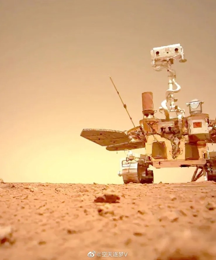
On the 20th November 2021 Saturday – 1330 to 1530 Hong Kong SAR- Beijing Time One of leading international Iconic Planetarium Space Museums 香港太空館Hong Kong Space Museum spoken in Chinese – Cantonese –Guangdong Dialect .. live streaming in one of its Auditorium in which Hong Kong SAR Space Program thorough outs it’s Universities collaborated in China- People’s Republic of China’s first most Challenging Mars Mission in which China’s CNSA –China National Space Administration skill set far out weight NASA’s Mar Missions current and past.. . In One of Hong Kong SAR Universities, Hong Kong PloyU has contributed the Camera system of Tianwen One’s one of many Camera systems also it’s Mars lander, Zhurong Mars rover, and Mars Orbiter other elementally equiment system…. Speaker: Prof. Yung Kai-leung, BBS (Chair Professor & Associate Head, Department of Industrial and Systems Engineering, The Hong Kong Polytechnic University)
The Tianwen-1, China’s first Mars mission successfully landed on it in May, achieving another extraordinary feat in the recent Chinese Aerospace Industry. This first Mars exploration mission of China is unique that employed novel technology and engineering design and encounters exceptional challenges.
The Tianwen-1, China’s first Mars mission successfully landed on it in May, achieving another extraordinary feat in the recent Chinese Aerospace Industry. This first Mars exploration mission of China is unique that employed novel technology and engineering design and encounters exceptional challenges.
The Mars Landing Surveillance Camera (Mars Camera) is developed mainly by the research team of the Hong Kong Polytechnic University. It is a sophisticated space instrument mounting on the top surface of the lander platform of Tianwen-1, which monitors the landing status, the surrounding environment of the red planet and the operation status of the Zhu Rong rover. The Mars Camera is light in weight, yet strong and durable enough to withstand the huge impact shocks of 6,200 times Earth’s gravity. Moreover, it has to operate under low Martian temperature as well as overcome extreme temperature differences it experienced during its flight. In this lecture, Professor Yung from the Hong Kong Polytechnic University will talk about the challenges of the Mars mission and delineate the contributions of the Hong Kong research team.
酒泉衛星發射中心On 23rd November 2021 Tuesday 07:45 Hong Kong SAR – Beijing Time morning, CNSA –China National Space AdministrationJiuquan Satellite Launch Center – Inner Mongolia – China – People’s Republic of China successfully Launched the International Iconic Chang Zheng 4B – Long March 4B Bingyao 37 44.1 Meter Tall Carrier Rocket in Successfully Deploying Gaofen-3 02 at the 9401 station of the Jiuquan Satellite Launch Center to successfully launch the Gaofen-3 02 Remote Sensing Satellite launched into space. The satellite successfully entered the scheduled sun-synchronous orbit, and the launch mission was a complete success. This is the 147th flight of the Long March series of carrier rockets developed by the Eighth Academy of Aerospace, the 398th launch of the Long March series of carrier rockets, the 21st launch of the Eighth Academy in 2021, the 41st launch of Aerospace Science and Technology Corporation, and the 45th launch of China Aerospace. , The 117th global aerospace launch.
Gaofen-3 02 Star Mission Badge Interpretation Gaofen-3 is the originally planned Ocean-3 sea-land radar satellite, and the current Ocean-3 has become a new generation of marine aqua stars. HY-3A and HY-3B are expected to be in 2022 and launched in 2023, and the Ocean No. 1 and No. 2 series are the first generation of ocean aqua observation stars and ocean dynamic observation stars, respectively.
Gaofen-3 02 satellite will be networked with 01 satellite to improve marine ship observation and maritime emergency monitoring capabilities] Gaofen-3 02 satellite is the “National Civil Space Infrastructure Mid- and Long-term Development Plan (2015-2025) )”, a microwave remote sensing satellite developed by the General Department of Remote Sensing Satellites of the 5th Academy of China Aerospace Science and Technology Group . It operates at an altitude of 755 kilometers and is sun-synchronous and returns to a frozen orbit. The main load is C-band synthetic aperture radar. 12 conventional imaging modes.
In August 2016, the Gaofen-3 01 satellite was successfully launched into space. It has been in orbit for 5 years with excellent performance and good application status. Gaofen-3 02 fully inherits the technical scheme of Gaofen-3 01. After launching into orbit, it will be networked with the orbiting Gaofen-3 satellite to form a land-sea radar satellite constellation with a resolution of 1 meter. The ability to revisit in one day meets the needs of rapid revisiting of sea and land observations, and provides support for the commercial application of multi-polarized synthetic aperture radar satellite data.
In addition, 02 satellite also added the ship’s automatic identification signal receiving system and on-board real-time processing functions to improve the monitoring capabilities of marine ship observations and marine emergencies and the natural environment of the sea and land , which can meet the maintenance of marine rights, marine disaster prevention and mitigation, The application requirements of marine dynamic environmental monitoring and disaster reduction, land, environmental protection, water conservancy, agriculture and meteorology will realize the transition of synthetic aperture radar satellite data from demonstration applications to operational applications in China, serving the national maritime power strategy.
The CNSA China National Space Administration is responsible for the organization and management of the Gaofen-3 02 satellite project. The Earth Observation and Data Center of the National Space Administration is responsible for mission planning and data management. The Research Institute of Technology is responsible for the overall development of satellite systems and launch vehicle systems. The Satellite Launch and Measurement and Control System Department is responsible for the organization and implementation of the launch site and measurement and control system. The land observation satellite data center components are responsible for the construction and operation of the ground system according to their respective divisions of work. The Ministry of Natural Resources takes the lead The user department is responsible for the construction and operation of the application system
[It only takes 10 minutes for Gaofen-3 02 satellite to obtain data and deliver it to users] Gaofen-3 02 is not a simple “copy” of 01 satellite. Under the optimized design and full verification of the R&D team, 02 Satellite has achieved three major performance improvements and loaded two major “exclusive Devices”. , Stronger skills”, greatly improving the efficiency of on-orbit applications.
1. Three major performance improvements: 1) Extend imaging time to achieve “Longer Viewing”. Taking marine applications as an example, Gaofen-3 01 has become an important carrier for monitoring ocean internal waves. Ocean internal waves are a kind of fluctuations that occur in the interior of the ocean. They are very destructive and pose a serious threat to ocean engineering, oil rigs and submarine oil pipelines. However, the global ocean area is large, and the amount of information obtained by a single startup is limited. In order to meet the application requirements, the development team has extended the duration of a single startup of the 02 satellite in the ocean observation mode. In the same work, the monitoring range and the amount of information obtained by the 02 satellite of Gaofen-3 are twice that of the 01 satellite, especially for ocean internal wave monitoring. Sufficient ocean internal wave change data can be obtained during the imaging time for early warning and prevention. Respond in a timely manner.
2) Optimize the imaging mechanism to achieve “seeing more clearly”. As a radar star, the unique advantages of all-time and all-weather imaging make Gaofen-3 01 an important “helper” in emergency rescue. Encouraged by the Gaofen-3 01 satellite, in order to provide the application department with better-quality satellite images, the development team took the breakthrough of greatly reducing the “scallop effect” and proposed to make the 02 satellite a “shadow less light” in space. The optimization idea of to achieve the uniform radiation observation target, to achieve a more three-dimensional topography of the detected image, a clearer presentation of the details, and a further expansion of the imaging range.
3) Shorten the revisit time and realize “seeing faster”. Taking scientific research as an example, in December 2019, the 36th Chinese Antarctic expedition team left Zhongshan Station on the “Xuelong” and headed to Hobart Port, Australia. The Gaofen-3 01 satellite provided high-resolution ship surrounding seas. The ice density and thickness, as well as the ice condition data in the sea area around Zhongshan Station, provide route planning for the safe navigation of the “Xuelong”. The 01 star at that time could only perform imaging once or twice a day. In the future, under the same conditions, the Gaofen-3 01 and 02 satellites will operate on the network, which will greatly shorten the time for revisiting, and can achieve more than 3 imaging in a single day, and obtain more data and faster.
2. Two “exclusive Devices”: One is to innovate and increase the AIS ship positioning technology, update the position information of marine ships in time, guide the imaging and identification of ships, and grasp the data of marine meteorology and navigation information in a timely manner, which will help protect life at sea Safe and improve the safety of navigation. The second is to increase the on-board real-time processor, which can perform data processing in a specific observation mode in real time, eliminating the “middleman” of data processing and directly “meeting” with users. In the past, it took a few hours for 01 Satellite to get the data to the user getting the image. 02 Star can process it within ten minutes-this is undoubtedly a huge leap for emergency rescue….
Images and visuals are from Weibo also their respectives.
中国空间站 On 8th November 2021 Hong Kong SAR – Beijing Time morning, the Belt and Road InitiativeCNSA –China National Space Administration CSS China Space Station in which on a three to six months setting up a new home of the first three Shenzhou 13 in which spending up to on for the further construction and verifications of the systems of the CSS –China Space Station 2021 launch calendar in which currently the three Takionauts current Shenzhou 13 …… Preparations for the six months of extension of the China Space Station In which the currently it remains awaiting for the crew of setting up home in conducting fun scientifically onboard中国空间站.. China Space station …..
Today on the 23rd November 2021 Shenzhou 13 crew member Takionaut王亞平 Wang Yaping in which taking the time out in keep fit in space, especially in Zero or Micro gravity in which without being presently of Gravity your body mass – bone Structure is risked healthy strength reduction so in space Takionauts- or personal working in space have to regularly exercise in orbit of space in fixed to almost Earth Gravity situation conditions to a tread mill helps the body strengthens the Bone Structure strength also muscle strength …… How beautiful is life on the China Space station? Astronaut Wang Yaping is both running in space and chasing watching her favourite Chinese dramas in orbit in which her Smart phone is fixed to a bracket with a full set of sports equiment.. ……..
previously 18th November 2021 Shenzhou 13 crew member Takionaut王亞平 Wang Yapingtaking the time out from work in which photographing stunning Earth Photography of the outlines of Earth landscape from orbiting around earth, there’s two that have been released photography from the core module Tianhe, Photographing stunning of the great rivers and mountain ranges of China- People’s Republic of China on a wintery season that’s currently season it’s in. Her Photography is release by China Manned Space Agency also photographing more as the Shenzhou 13 Crew orbits the planet Earth with a storytelling to tell of seeing through of what PLA SSF Senior Colonel 王亞平 Wang Yaping telling her stories of the first of six months of her stay on the China Space Station storytelling photographically to you from above of least 400 Kilometers above Earth.. In which storytelling those Breaths taking Stunning Photography of Planet Earth is storytelling through took a beautiful photo of the Earth with a Nikon D850 SLR in the Tianhe Core Module of Tiangong Space Station on November 18 among other stunning Earth Photography…!
Source: China’s Manned Spaceflight
Images and visuals are from Weibo also their respectives.