CNSA #ChinaNationalSpaceAdministration #國家航天局 |#BRI  #July2023 | #火星 # 天問 #天问一号#TianwenOne #MarsMission #Tianwen1 probe  #祝融号 #ZhuRong stunning Martian landscape new stunning photography during the year 2022  before Hibernation  #AGallery

天问一号飞運騎遊達达3亿CNSA – China National Space Administration – ESA – European Space agency Belt and road initiative mars mission…first Mars exploration mission, Tianwen- Martian Probe OneAs of September 15, 2022, the Tianwen-1 orbiter has been in orbit for more than 780 days, and the rover has travelled a total of 1,921 meters, completed the established scientific exploration tasks, and obtained 1,480 GB of original scientific exploration data. The scientific research team has obtained rich scientific results through the research on the first-hand scientific data obtained independently by my country. Through a comprehensive study of typical landforms such as concave cones, barrier craters, and trenches distributed in the landing area, the important connection between the formation of the above-mentioned landforms and water activities has been revealed.

朱融号  Zhurong Mars Rover The photos taken by the Mars rover before hibernation for one month (April 22), maybe this is the posthumous work…..The mosaic pictures of other scenes taken by Zhurong are all 50% of the original picture, and they were taken on January 29, March 3, March 14 and April 12, 2022.

It is worth mentioning that Figure 4 is the last batch of pictures from the navigation terrain camera of the Zhurong Mars rover currently released, and it may also be the last batch of photos from the Zhurong rover that we can see in the days to come Original..

Data source: The fourth batch of scientific exploration data of Tianwen-1 released by China Planetary Exploration Engineering Ground

On February 17, 2022, the Zhu Rong discovered an interesting-looking bunker (Figure 1). The ground around it is full of gravel, and most of it is sand here. On February 19th, the Zhurong sailed close to it to investigate it. Figure 2 is a collage of photos of the bunker taken on the side.


Source of original data: The fourth batch of scientific exploration data of Tianwen-1 released by China Planetary Exploration Engineering Ground Application System on July 3, 2023​​​​….

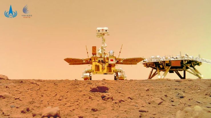
A selfie taken by the Zhu Rong rover on January 12, 2022, showing the back cover of the lander on the distant horizon.

Source of original data: The fourth batch of scientific exploration data of Tianwen-1 released by China Planetary Exploration Engineering Ground Application System on July 3, 2023​​​​….

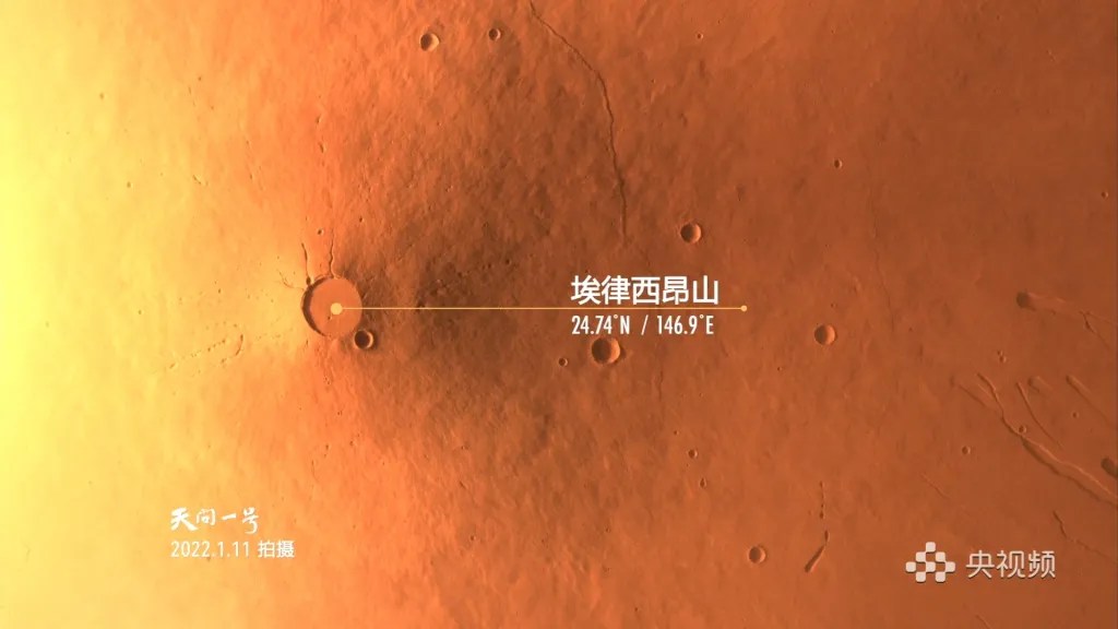
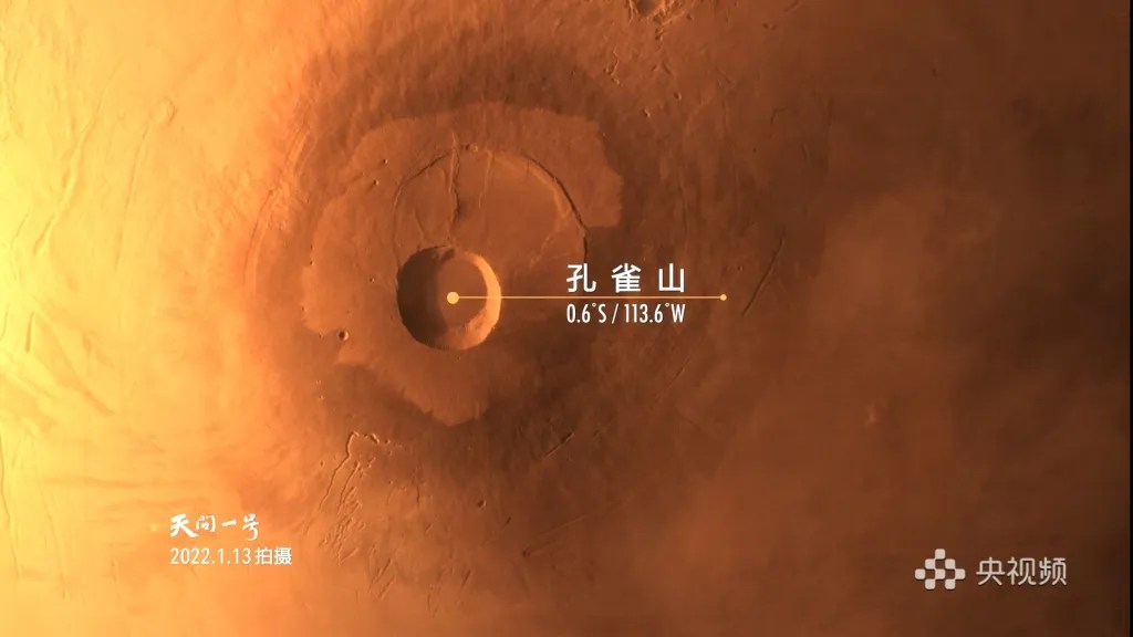
Four images of the surface of Mars acquired by the Tianwen-1 orbiter’s medium-resolution camera between January and February 2022. Do these four pictures look familiar to you? A little hint: the main scenery in the four photos are Peacock Mountain (Pavonis Mons), Arsia Mountain (Arsia Mons), Matt crater (Marth crater) on the Arabian Highlands (Arabia Terra) and Mount Elysium ( Elysium Mons).

That’s right, this is the documentary “Hello! Original images of the four photos of Mars in the opening credits of each episode of Mars. With the advancement of the Mars global image mapping work in 2022, the medium-resolution camera imaging area gradually moves southward to the middle and low latitudes. We have seen more and more shocking Mars photos, and we will slowly share them with you.

Original data source: The fourth batch of scientific exploration data of Tianwen-1 released by the China Planetary Exploration Engineering Ground Application System on July 3…

Tharsis Tholus, taken by the medium-resolution camera of Tianwen-1 on January 26, 2022, is a small shield volcano at 90.69° west longitude and 13.25° north latitude on Mars. Source of original data: The fourth batch of scientific exploration data of Tianwen-1 released by China Planetary Exploration Engineering Ground Application System on July 3, 2023

Tractus Catena, long and narrow in the Arcadia region of the northern hemisphere A group of pits located between the Alba Mountains and the Asklaw Mountains, with a total length of nearly 900 kilometers.
This picture is made by mosaicing 21 orbiter medium-resolution camera (MoRIC) images, taken from February to March 2022-detection cycle 845,998, and processed using OpenCV, SKImage, and Lr. [CAS/GRAS, CNSA/PEC; export production

Noctis Labyrinthus (Noctis Labyrinthus), taken by the medium-resolution camera of the Tianwen-1 orbiter on February 21, 2022, is a complex canyon in the western section of the Grand Canyon Mariners on the surface of Mars, shaped like a maze. In fact, the Latin name Labyrinthus of this type of landform means “maze at night”, and the Chinese translation of some places is directly called “maze”. Data source: The fourth batch

of scientific exploration data of Tianwen-1, the ground application system of China Planetary Exploration Engineering

The Tianwen-1 medium-resolution camera took the wind-eroded landform on the surface of Mars at 65.4° east longitude and 5.1° north latitude on February 17, 2022 (40% original resolution). Each impact crater bears traces of wind erosion, as if meteors flew over the surface of Mars. The reason for this landform is the accumulation of wind and sand formed under the action of the prevailing wind direction. The fourth batch of scientific exploration data of Tianwen-1 released by China Planetary Exploration Engineering Ground Application System on July 3, 2023.

Images and visuals are from their respectives  CNSA China National Space AdministrationCLEP China Lunar Exploration Program.

CNSA #ChinaNationalSpaceAdministration #國家航天局 |#BRI  #September2022 | #火星 # 天問 #天问一号#TianwenOne #MarsMission #Tianwen1 probe  #祝融号 #ZhuRong #Tianwen1 Symposium on Scientific Research Achievements of the First Mars Exploration Mission Held…

Symposium on Scientific Research Achievements of the First Mars Exploration Mission Held

​​On September 16, 2022, the first seminar on scientific research achievements of Mars exploration missions was held in Beijing in a combination of online and offline methods, aiming to strengthen the exchange of scientific research results of Tianwen-1.

Figure 1. Landform map of impact craters, concave cones, grooves and ridges in the Zhurong landing area

 天问一号飞運騎遊達达3亿CNSA – China National Space Administration – ESA – European Space agency Belt and road initiative mars mission…first Mars exploration mission, Tianwen- Martian Probe One As of September 15, 2022, the Tianwen-1 orbiter has been in orbit for more than 780 days, and the rover has travelled a total of 1,921 meters, completed the established scientific exploration tasks, and obtained 1,480 GB of original scientific exploration data. The scientific research team has obtained rich scientific results through the research on the first-hand scientific data obtained independently by my country. Through a comprehensive study of typical landforms such as concave cones, barrier craters, and trenches distributed in the landing area, the important connection between the formation of the above-mentioned landforms and water activities has been revealed.

Fig. 2 Schematic diagram of the plate-like hard-shell rock rich in water-bearing minerals found in the landing area by Zhurong and its formation process under the action of groundwater

Through camera images and spectral data, hydrous minerals were found in plate-like hard-shell rocks near the landing area, proving that there has been a large amount of liquid water activity in the landing area since 1 billion years ago (late Amazonian period).

Combined with camera images and rover moving ruts and other information, it is found that the soil in the landing area has strong compressive strength and low friction parameters, which are related to water activity and experience sand erosion.

Fig. 4 Analysis results of Martian soil mechanical parameters in the landing area of ​​Zhurong

These new results reveal the impact of Martian sandstorm and water activities on geological evolution and environmental changes, provide strong support for the conjecture that there was an ocean in the Martian Utopian Plain, and enrich human scientific understanding of Martian geological evolution and environmental changes. The relevant results have been published in authoritative academic journals at home and abroad such as “Nature Astronomy”, “Nature Geoscience”, “Science Advances”, “Science of China” and so on.

In addition, the scientific research team also used the detection data of Tianwen-1 to obtain a batch of data on the relationship between the density of rocks on the surface of Mars and the degree of surface erosion, the distribution of ions and neutral particles in the near-fire space environment, and the gravitational field of Mars. Excellent scientific results.

At present, the Tianwen-1 orbiter continues to carry out scientific exploration in the orbit of the remote sensing mission, continues to accumulate first-hand scientific data, and makes China’s contribution to mankind’s in-depth understanding of Mars.
 ​​​​

Images and visuals are from CNSA China National Space AdministrationCLEP China Lunar Exploration Program.

#CNSA #ChinaNationalSpaceAdministration #國家航天局 |#BeltAndRoadinitiative #July2022 | #火星 # 天問 #天问一号#TianwenOne #MarsMission #Tianwen1 probe  On the second anniversary of the launch of Tianwen-1, high-definition images of #Planet #Mars #MartianMoon #Phobos were sent back ….

天问一号飞運騎遊達达3亿CNSA – China National Space Administration – ESA – European Space agency Belt and road initiative mars mission…first Mars exploration mission, Tianwen- Martian Probe One on 23rd July 2022 On the second anniversary of the launch of Tianwen-1, high-definition images of Phobos were sent back

23 July 2022 Today is the second anniversary of the launch of the Tianwen-1 mission, and the orbiter returned Phobos images. Recently, the Tianwen-1 operation team seized the opportunity when the orbiter was relatively close to Phobos, used a high-resolution camera to image Phobos, and obtained a clear image of the “full moon” state.


Phobos (Forbes) is one of the two natural satellites of Mars, with a size of about 27 kilometers × 22 kilometers × 18 kilometers. It runs in a near circular orbit at an altitude of about 6,000 kilometers from the surface of Mars, and orbits Mars every day. about 3 turns. The orbiter runs on a polar elliptical orbit with an altitude of about 220 kilometers near the fire point and an altitude of about 10,800 kilometers at the far fire point with a period of about 7 hours. Due to the orbital relationship between Phobos and the orbiter, as well as the lighting requirements during imaging, the operation team made precise calculations and precise control, and obtained a clear image with a resolution of about 50 meters when the two were about 5,100 kilometers apart.

The image shows that Phobos is a small celestial body with irregular shape, in the shape of a potato. The stripes on the surface can be seen in the upper left of the picture, which may be formed by the impact of the impact process. There is an obvious impact crater in the upper right of the picture, with a diameter of about 2 kilometer, named Öpik crater (Upik was an Estonian astronomer, known for his research on asteroids and meteorites).

Another satellite of Mars is Deimos (Deimos), with an average radius of only about 6.2 kilometers. The two satellites are named after the two sons of Ares, the god of war in ancient Greek mythology. The Greeks used to call Mars by Ares. Both moons are small irregular objects that many scientists believe were captured by Mars’ gravity into Mars’ orbit, but their origins remain controversial.

 Image: National Astronomical Observatory​​​​…

Images and visuals are from CNSA- China National Space Administration also from there respectives- CLEP –China Lunar Exploration Project..

CNSA #ChinaNationalSpaceAdministration #國家航天局 |#BeltAndRoadinitiative #June2022 | #火星 # 天問 #天问一号#TianwenOne #MarsMission #Tianwen1 probe  #祝融号 #ZhuRong #Tianwen1 completes the established scientific exploration mission…

Tianwen-1 completes the established scientific exploration mission

天问一号飞運騎遊達达3亿CNSA – China National Space Administration – ESA – European Space agency Belt and road initiative mars mission…first Mars exploration mission, Tianwen- Martian Probe One ​​​As of June 29, 2022, the Tianwen-1 mission orbiter has been flying normally for 706 days, and has acquired medium-resolution image data covering the entire world of Mars. All scientific payloads have achieved global exploration of Mars. Both the Tianwen-1 mission orbiter and the Mars rover have completed the established scientific exploration missions.

The Tianwen-1 mission was approved by the Party Central Committee in January 2016, and was successfully launched on July 23, 2020. After a deep space flight of 475 million kilometers for 202 days, the probe will rendezvous with Mars on February 10, 2021, and successfully implemented the capture and braking to enter the orbit around Mars. After 3 months of detailed inspection of the pre-selected landing area, the Mars landing was successfully carried out on May 15, 2021. On May 22, the “Zhurong” rover successfully landed on the surface of Mars and began to patrol and explore.

On August 15, 2021, the “Zhurong” rover successfully completed the 90 Martian scientific exploration missions, and continued to carry out extended exploration missions. It has traveled 1,921.5 meters on the surface of Mars. Affected by the severe winter cold and dusty weather in the landing area, the rover will enter the winter dormancy mode on May 18, 2022 as designed. Around December 2022, the “Zhurong” landing area will enter the early spring season. will resume normal work.

The orbiter has circled Mars 1,344 times, achieving global coverage and is currently in normal condition. In the follow-up, it will continue to carry out global remote sensing detection, and choose an opportunity to carry out expansion technology experiments to carry out preliminary technical verification for related tasks.

After nearly two years of flight and exploration for the Tianwen-1 mission, the 13 scientific payloads deployed by the rover and orbiter have obtained a total of about 1040GB of raw scientific data. After receiving and processing on the ground, the standard scientific data products formed are submitted to the rover on a monthly basis. A team of scientists has conducted analysis and interpretation, and relevant scientific results have been published in well-known academic journals at home and abroad. These scientific data will be open to scientists around the world at an appropriate time. Scientists around the world are welcome to actively apply for research and jointly promote the cause of human exploration of the universe.

In the spirit of open and shared cooperation, the National Space Administration actively promotes cooperation with the space agencies and scientific communities of various countries, and shares the orbital data of its Mars orbiter with the National Aeronautics and Space Administration (NASA) and the European Space Agency (ESA) to carry out collision warning. Cooperation; the “Zhurong” Mars rover and the European Space Agency’s “Mars Express” orbiter carry out data relay communication experiments to realize China-Europe Mars scientific data relay cooperation; Observatory stations in other countries use the Tianwen-1 orbiter and the “Mars Express” orbiter to jointly carry out occultation observations of the sun and conduct scientific research such as solar wind. These cooperation have achieved good results, enriched human knowledge, and made positive contributions to the construction of a community with a shared future for mankind in the scientific field.
 

Below is a recent image of Mars taken by Tianwen-1. 

Figure 1 The image of Mount Askela taken by the center camera, with a diameter of 456 kilometers and a height of 18 kilometers , shows the characteristics of the crater on the top of Mount Askela, and there are multiple crater collapse events.
Figure 2 An image of the Antarctic ice sheet taken by the center camera. The image shows the polar cap of the Martian South Pole. The study believes that the long-term and permanent polar cap of the Martian poles is mainly composed of dry ice (solid carbon dioxide) and water ice.

Figure 3 The central point camera captures the western landform image of the Sailor Grand Canyon. The Sailor Grand Canyon extends over 4,000 kilometers from east to west, 150 kilometers to 700 kilometers from north to south , and the deepest can reach 7 kilometers .
Figure 4. The image of the Arabian Highlands impact crater taken by the camera in the middle point. The image shows the geomorphological features of dozens of impact craters distributed in the area.

Figure 5 The image of the edge of the Mond ring crater captured by a high-resolution camera with a spatial resolution of about 0.5 meters and a diameter of about 91 kilometers . The image shows the geomorphological features of the edge of the Mond ring crater. The lower left part of the picture is the inside of the ring crater. The edge of the pit can be seen clearly collapsing into the pit.
Figure 6 The image of the inspection area taken by Zhurong. The image was taken before the rover entered the winter dormancy state, showing the local characteristics of a dune landform in the inspection area.

Images and visuals are from CNSA- China National Space Administration also from there respectives- CLEP –China Lunar Exploration Project..

CNSA #ChinaNationalSpaceAdministration #國家航天局 |#BeltAndRoadinitiative #May2022 | #火星 # 天問 #天问一号#TianwenOne #MarsMission #Tianwen1 probe  #祝融号 #ZhuRong #Tianwen1 #CCTV #HelloMars Episode Five What skills does it take to drive on Mars? See how the Zhurong rover visits Mars Hello Mars

“Hello! Mars” Episode 5 What skills do you need to learn to drive on Mars? See how the Zhurong rover visits Mars Hello Mars…….!

On the months week of 19th May 2022   天问一号飞運騎遊達达3亿CNSA – China National Space Administration – ESA – European Space agency Belt and road initiative mars mission…first Mars exploration mission, Tianwen- Martian Probe One sent back stunning images of the Half Earth Mass size of the Rustic Planet Mars in which show stunning Martian landscape with its iconic polar caps of either southern or northern … With its timeless Stunning Mars Photography. Tianwen-1″ returned high-resolution images of the Mars inspection area The “Zhurong” rover is preparing for winter, and the orbiter continues to carry out orbital exploration….. in which one year ago it was it’s first landing on Utopia Planitia region on the planet Mars .. in celebrating a CCTV five part Episode was produced..

《你好!火星》Hello Mars Episode five  Two Driving on Earth pays attention to “there are thousands of roads, and safety is the first”, but on Mars, it becomes “there is no road, and safety is more important”. This place in the southern part of the Utopia Plain, although it is flat and open as far as the eye can see, is full of small pits and sand dunes. Driving in this place requires not only superb driving skills, but more importantly, a good car with eighteen martial arts skills. The rover’s design team finally designed this good car with experience and bold innovation.

本期内容:在地球上开车讲究“大路万千条,安全第一条”,在火星上就变成了“大路没一条,安全更重要”。乌托邦平原南部这块地方,虽然一望无际平坦开阔,但石块小坑沙丘比比皆是,在这种地方行车不仅需要车技高超,更重要的是需要一辆具有十八般武艺的好车。火星车的设计团队凭着经验和大胆创新最终设计出了这辆好车。

Hello everyone, I would like to tell you some good news about the documentary “Hello!” about China’s first Mars exploration mission. “Mars” is finally on the air, friends who want to know more about Mars can stay in front of the TV tonight

“Hello! “Mars” is a large-scale scientific documentary jointly produced by the National Space Administration and China Central Radio and Television to commemorate the first anniversary of the Tianwen-1 Mars probe’s successful landing on Mars. It took three years to complete the filming and is divided into “Departure” and “Journey” “Surrounding”, “Landing” and “Patrol” have 5 episodes, each of which is 30 minutes long. They focus on the important stages of the Tianwen-1 mission, and describe a large number of astronomy, astrophysics, space applications, aerospace engineering and other disciplines in a simple way. Knowledge, in-depth analysis of Chinese wisdom and Chinese solutions in Mars exploration. Since May 2020, the co-production team has continued to track the key nodes of the Tianwen-1 mission, filmed many wonderful moments, and obtained a large number of first-hand precious materials. Many of the contents of the documentary were made public for the first time and were released authoritatively.


Broadcasting plan CCTV-1 CCTV integrated channel every night at 22:36, five days of continuous broadcast from May 18th to 22nd; CCTV-10 CCTV science and education channel every night at 20:10, from May 19th to 23rd five days of continuous broadcast

大家好,告诉大家一个好消息,讲述中国首次火星探测任务的纪录片《你好!火星》终于要开播啦,想更多了解火星的朋友们今晚可以守在电视机前哟《你好!火星》是为纪念天问一号火星探测器成功着陆火星一周年,由国家航天局和中央广播电视总台联合出品的大型科学纪录片,共历时3年摄制完成,分为《出发》《征途》《环绕》《着陆》《巡视》5集,每集30分钟,分别聚焦天问一号任务的重要阶段,以深入浅出的形式讲述了大量天文学、天体物理学、空间应用学、航天工程学等学科知识,深度解析了火星探索中的中国智慧、中国方案。联合摄制团队自2020年5月起,持续跟踪天问一号任务关键节点,拍摄众多精彩瞬间,获得大量一手珍贵素材,纪录片中很多内容是首次公开,并权威发布。


播出计划CCTV-1央视综合频道 每晚22:36,5月18日至22日五天连播;CCTV-10央视科教频道 每晚20:10,5月️19日至23日五天连播

Images and visuals are from CNSA- China National Space Administration also from there respectives- CLEP –China Lunar Exploration Project..