#CNSA #ChinaNationalSpaceAdministration #国家航天局 |#BeltAndRoadinitiative #September 2020 | Yellow Sea based Launching the International Iconic #LongMarch11 #ChangZheng11 #CarrierRocket Deploying the #EarthSciences #Communications #Jilin1 #Gaofen03 #Satellites into orbit..

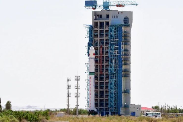
On a Tuesday 0923 Morning Beijing Time on the 15th September 2020, CNSA – China National Space Administration launched from a mobile sea based platform in the Yellow Sea China People’s Republic Of China…. Launching on a very fine sheerness cloudy day from the Sea Based Launching platform is Launching of the  Iconic Long March 11-Chang Zheng 11 Carrier Rocket.. Successfully of its two onboard payloads in deployment orbits deploying Jilin One 03-1 also Gaofen 03 Satellites both are Earth Sciences – Optical –Remote sensing Satellites …. Successfully sent Jilin-1 Gaofen 03 satellites into a 535-kilometre sun-synchronous orbit …. This launch makes this mission is the 346th launch of the Long March series of carrier rockets….The launch mission was specifically organized and implemented by the Taiyuan Satellite Launch Center, and the Long March 11 marine launch vehicle was developed and produced by the Aerospace Science and Technology Group Co..


Among there was another payload onboard it including “Beep Bilibili” The 3 video imaging mode satellite imaging mode satellites, including “Video Satellites” and “Central Video Satellites”, are mainly used to obtain high-resolution visible light push-broom images and video images, which will be China’s land resources Provide remote sensing services for census, urban planning, disaster monitoring….

Gaofen Satellite Constellation series is an optical remote sensing satellite with a ground pixel resolution of up to sub-meter level. It is mainly used in territorial census, urban planning, land right confirmation, road network design, crop yield estimation, and disaster prevention and mitigation. , Which can provide information guarantee for the construction of the “Belt and Road”…..

The Gaofen  manufacturer is CAST – China Academy of Space Technology also in collaboration with its associate agency with CHEOS- China High Resolution Earth Observation System in which is design Built on a CAST 2000 Design Heritage Earth Sciences, in which is design for Translating Gaofen is High Resolution, also known as CHEOS- China High Resolution Earth Observation System, in which provisions in the real time observational data analysis of with high resolution multi spectra equipment imaging system in analysis for assessing environmental disaster warning, emergency response also for the protection for ecological, also providing support for infrastructure construction, transportation for various purpose of the Belt And Road initiative  … one of many specifications of the Gaofen 10 Earth Sciences satellite is The high-resolution satellite is a large-scale remote sensing satellite system for the national science and technology major special arrangement of the microwave remote sensing satellite, the ground pixel resolution is up to sub-meter …

Jilin Satellite Constellation … manufactured by satellite was developed by Changguang Satellite Technology Co., Ltd., In which are designated as Earth Sciences remote satellites in which are provisionments with providing observationally data analysis of forestry, marine navigation, weather disaster forecasting management for its clients.. In which it forms a constellation network further of currently of thirteen… satellite is developed by the Chang Guang Satellite Technology Co., Ltd., in which also featuring a high resolution high data velocity broadband communications transmission.. Also, featuring a highly advance new optical earth sciences remote sensing observations..

Images and visuals are from Weibo.

#CNSA #ChinaNationalSpaceAdministration #国家航天局 | #BeltAndRoadinitiative #September2020 | #TaiyuanSatelliteLaunchCenter #太原衛星發射中心 Launches successfully of the Ionic #LongMarch4B #ChangZheng4B #CarrierRocket deploying #Gaofen11 02 the #EarthSciences #RemoteSensing #Satellite #OpticalSatellite …..


On a very clear moderately cloudy day of 7th September 2020 Monday on 1357 Beijing time launching on from Taiyuan Satellite Launch Center太原衛星發射中心 Shanxi Province-China- People’s Republic of China… Launching is from one of CNSA – China National Space Administration is the Chang Zheng4B –Long March 4B Carrier Rocket  in which sending an Earth Sciences- remote sensing Gaofen 11 -02 Satellite into scheduled orbit ….  In which this launch is the 345th Launched of the International iconic Long March Series Carrier Rocket Successfully..

Gaofen 11 02 is an optical remote sensing satellite with a ground pixel resolution of up to sub-meter level. It is mainly used in territorial census, urban planning, land right confirmation, road network design, crop yield estimation, and disaster prevention and mitigation. , Which can provide information guarantee for the construction of the “Belt and Road”…..

The Gaofen11 02 manufacturer is CAST – China Academy of Space Technology also in collaboration with its associate agency with CHEOS- China High Resolution Earth Observation System in which is design Built on a CAST 2000 Design Heritage Earth Sciences, in which is design for Translating Gaofen is High Resolution, also known as CHEOS- China High Resolution Earth Observation System, in which provisions in the real time observational data analysis of with high resolution multi spectra equipment imaging system in analysis for assessing environmental disaster warning, emergency response also for the protection for ecological, also providing support for infrastructure construction, transportation for various purpose of the Belt And Road initiative  … one of many specifications of the Gaofen 10 Earth Sciences satellite is The high-resolution satellite is a large-scale remote sensing satellite system for the national science and technology major special arrangement of the microwave remote sensing satellite, the ground pixel resolution is up to sub-meter …

Images and visuals are from Weibo 

#CNSA #ChinaNationalSpaceAdministration #国家航天局 | #BeltAndRoadinitiative #June2020| #JIUQUANSATELLITELAUNCHCENTER #酒泉衛星發射中心 – Launching of the iconic #LongMarch2D #ChangZheng2D #CarrierRocket deploying the #Gaofen9 #RemoteSensingSatellite #HeadSatellite #Pixing3 #PicoSatellite…

On a late afternoon 1519 Afternoon Beijing Time  On 17th June, 2020 launching from the CNSA – China National Space Administration one of many launch complexes  launching from Jiuquan Satellite Launch Center in which located in Inner Mongolia China – People’s Republic Of China ..  , in which CNSA launching of the Iconic Long March 2D – Chang Zheng 2D carrier rocket at the Jiuquan Satellite Launch Center…… This mission is the 335th flight of the Long March series of launch vehicles.

The launch of the Iconic Long March 2D – Chang Zheng 2D Carrier Rocket launched successfully in which deploying three satellites in which deploy the advance remote sensing satellite Gaofen Nine number three… Also two more a PicoSatellite named Pixing three also Head Five Satellite… in which the Head Satellite is designed as fifth Automated Identification System (AIS) services satellite for private company HEAD Aerospace. It will carry out on-orbit global AIS vessel data collection and ADS-B flight data monitoring…… the Pico Satellite is testing platform for Zhejiang University……

The Main payload is a Gaofen Nine number three remote Sensing Satellite….. Gaofen No. 9 03 is an optical remote sensing satellite with a ground pixel resolution up to sub-meter level. It is mainly used in areas such as land census, urban planning, land rights determination, road network design, crop estimation and disaster prevention It can provide information guarantee for the construction of the “Belt and Road”. The launch of the Head 5 satellite was developed by Beijing Head Aerospace Technology Co., Ltd., and can carry out global ship navigation status collection, global flight status collection and global Internet of Things information collection on orbit.

The Gaofen Satellite  manufacturer is CAST – China Academy of Space Technology also in collaboration with its associate agency with CHEOS- China High Resolution Earth Observation System in which is design Built on a CAST 2000 Design Heritage Earth Sciences, in which is design for Translating Gaofen is High Resolution, also known as CHEOS- China High Resolution Earth Observation System, in which provisions in the real time observational data analysis of with high resolution multi spectra equipment imaging system in analysis for assessing environmental disaster warning, emergency response also for the protection for ecological, also providing support for infrastructure construction, transportation for various purpose of the Belt And Road initiative  … one of many specifications of the Gaofen  Earth Sciences satellite is The high-resolution satellite is a large-scale remote sensing satellite system for the national science and technology major special arrangement of the microwave remote sensing satellite, the ground pixel resolution is up to sub-meter …

Image and visuals are from Weibo..

#CNSA #ChinaNationalSpaceAdministration #国家航天局 | #BeltAndRoadinitiative | #LongMarch4C #ChangZheng4C | On National Day holiday week of the People’s Republic of China is the launch of the iconic reliable #CZ4C #CarrierRocket launch of #Gaofen10-2 #EarthSciences #Satellite ..


On the 5th October 2019 morning of 0251 Beijing Time, launching the iconic reliable CNSA China National Space Administration Long March 4C Carrier Rocket. In with launched to a distanced walking  gathering  to watching an early morning launch… launching from the Taiyuan Satellite Launch Center located in Northern China, Shanxi Province….   In which entered into a successful orbit form one of many CNSA Launch complex centres..

Launching the Iconic CNSA – Long March 4C or known as Chang Zheng 4C, manufactured by SAST- Shanghai Academy of Spaceflight Technology … launching the Long March 4C Carrier Rocket the staff working hard during their National Day seven day bank holiday.. In which working on National Day does not rest…. in which the launch and delivery of the Long March 4C with a Gaofen ten satellite..

The Gaofen10 manufacturer is CAST – China Academy of Space Technology also in collaboration with its associate agency with CHEOS- China High Resolution Earth Observation System in which is design Built on a CAST 2000 Design Heritage Earth Sciences, in which is design for Translating Gaofen is High Resolution, also known as CHEOS- China High Resolution Earth Observation System, in which provisions in the real time observational data analysis of with high resolution multi spectra equipment imaging system in analysis for assessing environmental disaster warning, emergency response also for the protection for ecological, also providing support for infrastructure construction, transportation for various purpose of the Belt And Road initiative  … one of many specifications of the Gaofen 10 Earth Sciences satellite is The high-resolution satellite is a large-scale remote sensing satellite system for the national science and technology major special arrangement of the microwave remote sensing satellite, the ground pixel resolution is up to sub-meter …

 Image and visual credits are from Weibo- (Photographing: Li Jian, Lu Hao)

#CNSA China National Space Administration |#BeltAndRoadinitiative – #LongMarch4B Carrier Rocket launches the #Gaofen11 high advanced remote sensing satellite for Earth Sciences..

CNSA – China National Space Administration – successfully launched a Long March 4B series Carrier Rocket for Earth Sciences- Gaofen eleven

On a very summery northern China Tuesday,  31st July 2018, the eve day before August 2018, CNSA – China National Space Administration have successfully launched a very reliable Long March 4B series Carrier Rocket from one of many CNSA’s Space Launch Complexes in which its Taiyuan Satellite Launch Center in Northern China’s Shanxi Province..

The 282nd flight of Launching from the Carrier Rocket, The Long March 4B, the three stages Long March launched at 1100 hours Beijing or Hong Kong Time.. Launched from Space launched Complex nine.. From the Taiyuan Satellite launch Center launching the Gaofen11 satellite into sun synchronous polar orbit by those powerful mightily four YF-20B engines..  in which provide flight time in between ten to twenty minutes.. as it making its way to delivery to position Gaofen11 satellite..


CNSA China National Space Administration – launching the Gaofen eleven Earth Sciences Satellite providing support to the Belt And Road initiative….

The Gaofen11 manufacturer is CAST – China Academy of Space Technology also in collaboration with its associate agency with CHEOS- China High Resolution Earth Observation System in which is design Built on a CAST 2000 Design Heritage Earth Sciences, in which is design for Translating Gaofen is High Resolution, also known as CHEOS- China High Resolution Earth Observation System, in which provisions in the real time observational data analysis of with high resolution multi spectra equipment imaging system in analysis for assessing environmental disaster warning, emergency response also for the protection for ecological, also providing support for infrastructure construction, transportation for various purpose of the Belt And Road initiative  …….