#CNSA #ChinaNationalSpaceAdministration #国家航天局 |#BeltAndRoadinitiative #酒泉衛星發射中心 #JiuquanSatelliteLaunchCenter  #June2022| Successfully launching of the international Iconic #ChangZheng4C  #LongMarch4C #CarrierRocket of the # Gaofen12 three series #EnivormentalSatellites #EarthSciences #RemoteSensing #Satellites ….

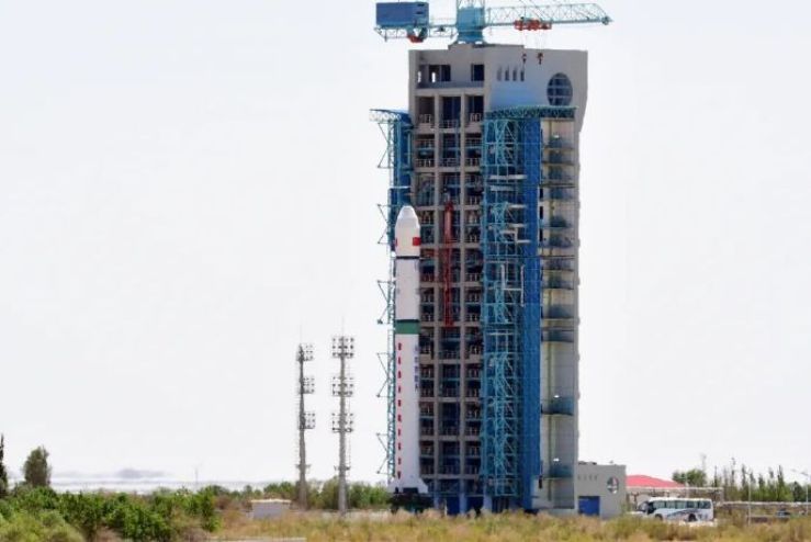
酒泉衛星發射中心On 27th June 2022 Monday 2346 late night Hong Kong SAR – Beijing Time  morning, CNSA –China National Space Administration  Jiuquan Satellite Launch Center – Inner Mongolia – China – People’s Republic of China successfully Launched the International Iconic Chang Zheng Long March 4C…. This launch is the 91st launch of the Long March 4 series of launch vehicles, the 160th launch of the Long March series of launch vehicles developed by the Eighth Academy, and the 425th launch of the Long March series of launch vehicles.

Successfully Launched the International Iconic Chang Zheng Long March 4C…. three environmental – Earth satellites the Gaofen 12 series of three Satellites into their pre-determined orbitation …. The satellite is mainly used for land census, urban planning, land rights confirmation and other fields in which the provisions of  satellite is mainly used in the fields of land census, urban planning, land rights confirmation, road network design, crop yield estimation and disaster prevention and mitigation. …


The newly improved advance Chang Zheng 4C Carrier Rocket carrier rocket used for this launch mission is a normal temperature liquid three-stage carrier rocket with excellent performance and wide application. It has the ability to launch satellites of various types and different orbits. Its sun-synchronous circular orbit has a carrying capacity of up to 3 tons (orbit height of 700 kilometers).

The Gaofen12 series Remote Sensing Earth Sciences Satellite manufacturer is CAST – China Academy of Space Technology also in collaboration with its associate agency with CHEOS- China High Resolution Earth Observation System in which is design Built on a CAST 2000 Design Heritage Earth Sciences, in which is design for Translating Gaofen is High Resolution, also known as CHEOS- China High Resolution Earth Observation System, in which provisions in the real time observational data analysis of with high resolution multi spectra equipment imaging system in analysis for assessing environmental disaster warning, emergency response also for the protection for ecological, also providing support for infrastructure construction, transportation for various purpose of the Belt And Road initiative  … one of many specifications of the Gaofen Earth Sciences satellite is The high-resolution satellite is a large-scale remote sensing satellite system for the national science and technology major special arrangement of the microwave remote sensing satellite, the ground pixel resolution is up to sub-meter …

Images and visuals are from Weibo also their respectives..

#CNSA #ChinaNationalSpaceAdministration #国家航天局 |#BeltAndRoadinitiative #October2020 | # XichangSatelliteLaunchCenter #西昌衛星發射中心Launches successfully of the advance variant Ionic #LongMarch3B #ChangZheng3B #CarrierRocket deploying #Gaofen13 the #EarthSciences #RemoteSensing #OpticalSatellite #Satellite …..

On a very dark Autumn pasting just of midnight with Xichang Satellite launch Center –  Sichuan province local residents crowds staying up celebrating Morning 0057 hour Beijing time on October 12th, 2020, watching a celebrating launch that celebrating China National Day also the Mid-Autumn festival in China – People’s Republic of China.  In which CSNA –China National Space Administration Successfully launched the Gaofen 13 satellite using the advance variant Long March 3B carrier rocket into schedule orbit deploying the Earth Sciences – Remote Sensing Optical Satellite The Gaofen 13 this marks the ., this launch is the 349th launch of the Long March series carrier rocket. (China Aerospace Science and Technology Corporation) the advance variant of the Long March 3B is . For this mission, the Long March IIIB launch vehicle has undergone the most technological changes in recent years-16 first-flight first-use technologies have been updated, mainly involving satellite fairings, on-arrow pressurized transport systems, and three-stage rocket igniters , Laser inertial group data with amongingly with other modified systems..  

 .

The Gaofen 13 satellite is a high-orbit optical remote sensing satellite, which is mainly used in fields such as land surveys and crop yield estimation. This mission is the 349th flight of the Long March series of carrier rockets…. The Gaofen 13 is an optical remote sensing satellite with a ground pixel resolution of up to sub-meter level. It is mainly used in territorial census, urban planning, land right confirmation, road network design, crop yield estimation, and disaster prevention and mitigation. , Which can provide information guarantee for the construction of the “Belt and Road Initiative.”

The Gaofen13  manufacturer is CAST – China Academy of Space Technology also in collaboration with its associate agency with CHEOS- China High Resolution Earth Observation System in which is design Built on a CAST 2000 Design Heritage Earth Sciences, in which is design for Translating Gaofen is High Resolution, also known as CHEOS- China High Resolution Earth Observation System, in which provisions in the real time observational data analysis of with high resolution multi spectra equipment imaging system in analysis for assessing environmental disaster warning, emergency response also for the protection for ecological, also providing support for infrastructure construction, transportation for various purpose of the Belt And Road initiative  … one of many specifications of the Gaofen 10 Earth Sciences satellite is The high-resolution satellite is a large-scale remote sensing satellite system for the national science and technology major special arrangement of the microwave remote sensing satellite, the ground pixel resolution is up to sub-meter …

Images and visuals are from Weibo….Also from 哈库纳玛塔塔_Si

#CNSA #ChinaNationalSpaceAdministration #国家航天局 |#BeltAndRoadinitiative #September 2020 | Yellow Sea based Launching the International Iconic #LongMarch11 #ChangZheng11 #CarrierRocket in preparations for two more launches from a marine launch vehicle..


Currently this week for the September 2020 schedule there are two more sea based launches from the Yellow Sea on China- People’s Republic of China… in which the Newly Modified Long March 11 –Cheng Zheng 11長征十一號運載火箭20.8 meters long Carrier Rocket in which has modifications of Chang-Zheng 11H series in which is mounted based on a DF-31 Missile type modifications in which the vehicle is launched from a tube delivery system from a road, or oceanic mobile vehicle platform..

Previously On a Tuesday 0923 Morning Beijing Time on the 15th September 2020, CNSA – China National Space Administration launched from a mobile sea based platform in the Yellow Sea China People’s Republic Of China…. Launching on a very fine sheerness cloudy day from the Sea Based Launching platform is Launching of the  Iconic Long March 11-Chang Zheng 11 Carrier Rocket.. Successfully of its two onboard payloads in deployment orbits deploying Jilin One 03-1 also Gaofen 03 Satellites both are Earth Sciences – Optical –Remote sensing Satellites….  deploying Nine Cube satellites into one launch…. Successfully sent Jilin-1 Gaofen 03 satellites into a 535-kilometre sun-synchronous orbit …. This launch makes this mission is the 346th launch of the Long March series of carrier rockets….The launch mission was specifically organized and implemented by the Taiyuan Satellite Launch Center, and the Long March 11 marine launch vehicle was developed and produced by the Aerospace Science and Technology Group Co….

Among there was another payload onboard it including “Beep Bilibili The 3 video imaging mode satellite imaging mode satellites, including “Video Satellites” and “Central Video Satellites”, are mainly used to obtain high-resolution visible light push-broom images and video images, which will be China’s land resources Provide remote sensing services for census, urban planning, disaster monitoring…. ……Gaofen Satellite Constellation series is an optical remote sensing satellite with a ground pixel resolution of up to sub-meter level. It is mainly used in territorial census, urban planning, land right confirmation, road network design, crop yield estimation, and disaster prevention and mitigation. , Which can provide information guarantee for the construction of the “Belt and Road”….. Jilin Satellite Constellation … manufactured by satellite was developed by Changguang Satellite Technology Co., Ltd., In which are designated as Earth Sciences remote satellites in which are provisionments with providing observationally data analysis of forestry, marine navigation, weather disaster forecasting management for its clients.. In which it forms a constellation network further of currently of thirteen… satellite is developed by the Chang Guang Satellite Technology Co., Ltd., in which also featuring a high resolution high data velocity broadband communications transmission.. Also, featuring a highly advance new optical earth sciences remote sensing observations..

Images and Visuals are from Weibo 

#CNSA #ChinaNationalSpaceAdministration #国家航天局 | #BeltAndRoadinitiative #June2020| #JIUQUANSATELLITELAUNCHCENTER #酒泉衛星發射中心 – Launching of the iconic #LongMarch2D #ChangZheng2D #CarrierRocket deploying the #Gaofen9 #RemoteSensingSatellite #HeadSatellite #Pixing3 #PicoSatellite…

On a late afternoon 1519 Afternoon Beijing Time  On 17th June, 2020 launching from the CNSA – China National Space Administration one of many launch complexes  launching from Jiuquan Satellite Launch Center in which located in Inner Mongolia China – People’s Republic Of China ..  , in which CNSA launching of the Iconic Long March 2D – Chang Zheng 2D carrier rocket at the Jiuquan Satellite Launch Center…… This mission is the 335th flight of the Long March series of launch vehicles.

The launch of the Iconic Long March 2D – Chang Zheng 2D Carrier Rocket launched successfully in which deploying three satellites in which deploy the advance remote sensing satellite Gaofen Nine number three… Also two more a PicoSatellite named Pixing three also Head Five Satellite… in which the Head Satellite is designed as fifth Automated Identification System (AIS) services satellite for private company HEAD Aerospace. It will carry out on-orbit global AIS vessel data collection and ADS-B flight data monitoring…… the Pico Satellite is testing platform for Zhejiang University……

The Main payload is a Gaofen Nine number three remote Sensing Satellite….. Gaofen No. 9 03 is an optical remote sensing satellite with a ground pixel resolution up to sub-meter level. It is mainly used in areas such as land census, urban planning, land rights determination, road network design, crop estimation and disaster prevention It can provide information guarantee for the construction of the “Belt and Road”. The launch of the Head 5 satellite was developed by Beijing Head Aerospace Technology Co., Ltd., and can carry out global ship navigation status collection, global flight status collection and global Internet of Things information collection on orbit.

The Gaofen Satellite  manufacturer is CAST – China Academy of Space Technology also in collaboration with its associate agency with CHEOS- China High Resolution Earth Observation System in which is design Built on a CAST 2000 Design Heritage Earth Sciences, in which is design for Translating Gaofen is High Resolution, also known as CHEOS- China High Resolution Earth Observation System, in which provisions in the real time observational data analysis of with high resolution multi spectra equipment imaging system in analysis for assessing environmental disaster warning, emergency response also for the protection for ecological, also providing support for infrastructure construction, transportation for various purpose of the Belt And Road initiative  … one of many specifications of the Gaofen  Earth Sciences satellite is The high-resolution satellite is a large-scale remote sensing satellite system for the national science and technology major special arrangement of the microwave remote sensing satellite, the ground pixel resolution is up to sub-meter …

Image and visuals are from Weibo..

#CNSA #ChinaNationalSpaceAdministration #国家航天局 |#BeltAndRoadinitiative #MAY2020 | #JiuquanSatelliteLaunchCenter #酒泉衛星發射中心| Behind the scenes of Launching of the Iconic #LongMarch2D- #ChangZheng2D #CarrierRocket deploying the #Gaofen #Hede #OpticalRemoteSensingSatellite #NavigationSatellite ….

On a late afternoon 16:53 Beijing Time  On May 31st, 2020 launching from the CNSA – China National Space Administration one of many launch complexes  launching from Jiuquan Satellite Launch Center in which located in Inner Mongolia China – People’s Republic Of China ..  , in which CNSA launching of the Iconic Long March 2D – Chang Zheng 2D carrier rocket at the Jiuquan Satellite Launch Center…… This mission is the 333th flight of the Long March series of launch vehicles.


Launching of the Long March 2D – Chang Zheng 2D successfully send the Gaofen No. 9 02 star and the Hede No. 4 satellite into a predetermined orbit…… the launch is a complete success. Gaofen No. 9 02 is an optical remote sensing satellite with a ground pixel resolution up to sub-meter level. It is mainly used in areas such as land census, urban planning, land rights determination, road network design, crop estimation and disaster prevention and mitigation.


Gaofen No. 9 02 is an optical remote sensing satellite with a ground pixel resolution up to sub-meter level. It is mainly used in areas such as land census, urban planning, land rights determination, road network design, crop estimation and disaster prevention It can provide information guarantee for the construction of the “Belt and Road”. The launch of the Hede-4 satellite was developed by Beijing Hede Aerospace Technology Co., Ltd., and can carry out global ship navigation status collection, global flight status collection and global Internet of Things information collection on orbit.


The Gaofen Satellite  manufacturer is CAST – China Academy of Space Technology also in collaboration with its associate agency with CHEOS- China High Resolution Earth Observation System in which is design Built on a CAST 2000 Design Heritage Earth Sciences, in which is design for Translating Gaofen is High Resolution, also known as CHEOS- China High Resolution Earth Observation System, in which provisions in the real time observational data analysis of with high resolution multi spectra equipment imaging system in analysis for assessing environmental disaster warning, emergency response also for the protection for ecological, also providing support for infrastructure construction, transportation for various purpose of the Belt And Road initiative  … one of many specifications of the Gaofen  Earth Sciences satellite is The high-resolution satellite is a large-scale remote sensing satellite system for the national science and technology major special arrangement of the microwave remote sensing satellite, the ground pixel resolution is up to sub-meter …

Image and visuals are from Weibo..