#CNSA #ChinaNationalSpaceAdministration #国家航天局 | #BeltAndRoadinitiative #June2020|#西昌衛星發射中心 #XichangSatelliteLaunchCenter – Launching of the International Iconic #LongMarch3B #LongMarch3B #CarrierRocket deploying the final advance #Beidou3 Third Generation Constellation Advance #NavigationSatellite System..


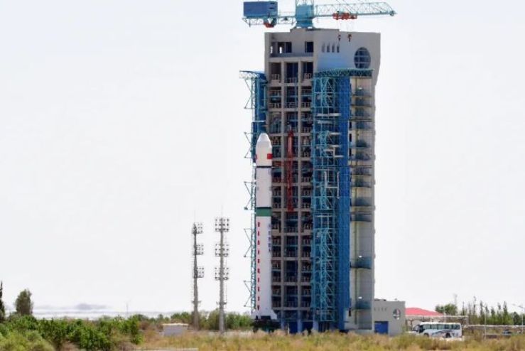
On the week of a very foggy 23rd June 2020 it’ll be the final extremely Advance third generation last BeiDou Navigation Satellite launched from the iconic Long March 3B – Chang Zheng 3B… in which the announcement was made on Sunday in which was to launch on the 15th June 2020 in which that day some technical issues in which that has been solved diligentingly   ..  Launching from one many CNSA – China National Space Administration launch center complexes … Launching from Xichang Satellite Launch Center located in Sichuan province in the Northwest China – People’s Republic of China…

On 14th June 2020 According to the China Satellite Navigation Office, the last BDS constellation satellite has completed the on-ground technical tests and the propellant filling,with the pre-launch status being set, at Xichang Satellite Launch Center. The Long March 3B launch vehicle for the mission has completed all pre-filling tests with all functions and performances qualifying for the mission requirements. Filling of the regular propellant and the cryogenic propellant is imminent and the launch will be carried out very soon.

The preparations for the launch of the Long March 3B- Chang Zheng 3B Carrier Rocket has been in process for the last two months least … The three series generations of the BeiDou Navigation Constellation System in which in layers of series of generation first towards third.. In which the third generation constellation has been a constellation of fifty nine satellites in which gradually progressively started two decades ago..

BDS – BeiDou satellite constellation, in which fifty two satellites experimental variants have entered, in which the next generation ones deployed replace the older generation earlier ones in service.. Providing servicement since year 2000 turn of the century onwards till the next generation of BDS systems comes to replace the network…

… Providing data, navigationally observational communications towards the Belt and Road Initiative countries in providing that delivery is the Long March 3B Carrier Rocket ….. The Carrier Rocket Long March 3B- 3B/E plus YZ1- YuanZheng one the secondary stage, is one of CNSA’s major reliable unmanned work trucks…Manufactured in China’s ancient capital Xi’an by China…

The final core BeiDou 3 Constellation series, in which are number fifty two and fifty three completes a constellation of While BDS-3 consists of three kinds of satellites, MEO, Inclined Geosynchronous Orbit (IGSO), and Geostationary Earth Orbit satellites (GEO)…. In which the categories of the GEO and IGSO satellites, BDS can provide enhanced positioning services in regions near China. The system can also provide short-message services, which other navigation satellite systems don’t have…

Manufactured, designed by CNSA’s network companies, CAST- China Academy of Sciences Technology , also CALVT- China Academy of Launch Vehicle Technology branch… Each BeiDou3 advance atomic clock in which it timely beats with the Rubidium Atomic clocks in which the frequency vibrations of the Rubidium atoms gives an extreme advance ultra-stable accurate timing….. BeiDou satellite network system name was inspired form the seven stars that occupied the big dipper that points towards the star Polaris, the Northern Pole Star… In which northern hemisperers navigate from also in Chinese legend it’s also the Fortress Mouth of the Tortoise gate the only entrance toward the upper domain, the gate of Heaven……  In which during the duration of 2020 the BDS constellation network would have an excess of thirty satellites servicing the provision requirement needs of the Belt and Road Initiative…..

With a coverage of the Asia Pacific region with a accuracy within ten meters that will get tighter towards as each generation innovates…in providing navigational communicational  services towards the Belt and Road initiative countries within 59 Satellite network by 2020…. in which the BeiDou Satellite Constellation system in which has been, installed since the year two thousand servicing the Asia Pacific region in the year 2012 from serving China… in which the system provides towards more than fifty countries with a total population of three billion people… Since year Two Thousand, since providing that service it helped rescuing more than ten thousand fishermen… Also provide monitoring the structural integrity of highways, pipelines, dams, bridges also various infrastructures…  As part of it Data Communications package It provide more than three hundred million smart phones in which thirty three percent of the Smart Phone market have now currently connected towards the BeiDou Constellation network..  Towards year 2020 the BeiDou Constellation system providing advance first high quality rated leading services for a global services..

Images and visuals are from Weibo

#CNSA #ChinaNationalSpaceAdministration #国家航天局 | #BeltAndRoadinitiative #June2020| #JIUQUANSATELLITELAUNCHCENTER #酒泉衛星發射中心 – Launching of the iconic #LongMarch2D #ChangZheng2D #CarrierRocket deploying the #Gaofen9 #RemoteSensingSatellite #HeadSatellite #Pixing3 #PicoSatellite…

On a late afternoon 1519 Afternoon Beijing Time  On 17th June, 2020 launching from the CNSA – China National Space Administration one of many launch complexes  launching from Jiuquan Satellite Launch Center in which located in Inner Mongolia China – People’s Republic Of China ..  , in which CNSA launching of the Iconic Long March 2D – Chang Zheng 2D carrier rocket at the Jiuquan Satellite Launch Center…… This mission is the 335th flight of the Long March series of launch vehicles.

The launch of the Iconic Long March 2D – Chang Zheng 2D Carrier Rocket launched successfully in which deploying three satellites in which deploy the advance remote sensing satellite Gaofen Nine number three… Also two more a PicoSatellite named Pixing three also Head Five Satellite… in which the Head Satellite is designed as fifth Automated Identification System (AIS) services satellite for private company HEAD Aerospace. It will carry out on-orbit global AIS vessel data collection and ADS-B flight data monitoring…… the Pico Satellite is testing platform for Zhejiang University……

The Main payload is a Gaofen Nine number three remote Sensing Satellite….. Gaofen No. 9 03 is an optical remote sensing satellite with a ground pixel resolution up to sub-meter level. It is mainly used in areas such as land census, urban planning, land rights determination, road network design, crop estimation and disaster prevention It can provide information guarantee for the construction of the “Belt and Road”. The launch of the Head 5 satellite was developed by Beijing Head Aerospace Technology Co., Ltd., and can carry out global ship navigation status collection, global flight status collection and global Internet of Things information collection on orbit.

The Gaofen Satellite  manufacturer is CAST – China Academy of Space Technology also in collaboration with its associate agency with CHEOS- China High Resolution Earth Observation System in which is design Built on a CAST 2000 Design Heritage Earth Sciences, in which is design for Translating Gaofen is High Resolution, also known as CHEOS- China High Resolution Earth Observation System, in which provisions in the real time observational data analysis of with high resolution multi spectra equipment imaging system in analysis for assessing environmental disaster warning, emergency response also for the protection for ecological, also providing support for infrastructure construction, transportation for various purpose of the Belt And Road initiative  … one of many specifications of the Gaofen  Earth Sciences satellite is The high-resolution satellite is a large-scale remote sensing satellite system for the national science and technology major special arrangement of the microwave remote sensing satellite, the ground pixel resolution is up to sub-meter …

Image and visuals are from Weibo..

#CNSA #ChinaNationalSpaceAdministration #国家航天局 |#BeltAndRoadinitiative #June2020 | #太原衛星發射中心 #TaiyuanSatelliteLaunchCenter – Successfully launching of the iconic #LongMarch2C #ChangZheng2C deploying successfully the #OceanographicSatellite #MarineSatellite #Ocean1D # HY1D #Haiyang1D #Satellite…..

On this day.. 11th June.. 图说宇宙史上的今日…… Shenzhou No. 10 spaceship, one of the Chinese Shenzhou series spacecraft, and the fifth manned spacecraft in China, was launched from the Jiuquan Satellite Launch Center at 17:38 on June 11, 2013. It is the last docking mission between Shenzhou spaceship and Tiangong-1. The Shenzhou ten missions has achieved the success of China’s manned spaceflight mission, and it has successfully concluded the second step of the first phase of the project…… Also On this day on too is also the launch of the international Iconic CNSA –China National Space Administration international Iconic Long March 2C –Chang Zheng 2C Carrier Rocket…  launching from the Taiyuan Satellite Launch Center, Shanxi Province, China –People’s Republic of China….. In which at 0213 hours Beijing Time in the early hours in the morning … launching successfully … Thursday’s launch was the 334th by the Long March rocket series.

During the observations of the launch from Taiyuan Satellite Launch Centre, in which it was observationally tracked by many tracking stations on from one in particular from the Sanya observation and control station of the Xi’an Satellite Measurement and Control Center discovered and tracked the target in time and successfully completed the measurement and control task. The follow-up Sanya measurement and control station will participate in the long-term management and control of the satellite as planned.

The Oceanographic Observation Satellite or Marine Observation Satellite in which it’s provisionments  will provide services to the marine environment monitoring and forecasting, marine hazard warning, marine rights enforcement and scientific research in which advance data gathering- analysis  enhancing the abilities of observing ocean colour, coastal resources and ecological environment, and ramp up support for meteorology, agriculture, water conservation and transportation…. In which will assist in help of combating climate change ….

Haiyang1D   short for HY-1D, China’s fourth remote-sensing satellite for ocean observation, carries five payloads that have similar functions as HY-1C. A scanner can observe ocean colour globally, and measure the surface temperature of the seas, every day, with a spatial resolution of 1.1 km……The imager can obtain coastal water environment, coastal zone and ecological environment of rivers and lakes with a spatial resolution of 50 meters, every three days…….. Also it’s also equipped with an automatic identification system for ships……

The data will be used for resource and environmental surveys, and to facilitate marine disaster prevention and mitigation, sustainable utilization of marine resources, early warning for marine ecology, and environmental protection……..The Haiyang1D satellite was developed by the DFH Satellite Co. Ltd. under the CAST- China Academy of Space Technology, in which the Long March – Chang Zheng Carrier rocket was produced by the CALVT China Academy of Launch Vehicle Technology.

Images and visuals are from Weibo