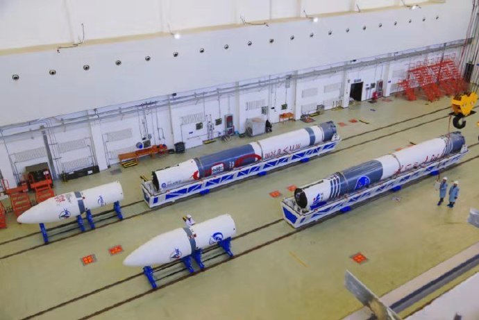
#CNSA #ChinaNationalSpaceAdministration #国家航天局 |#BeltAndRoadinitiative #MAY2020 | #JiuquanSatelliteLaunchCenter #酒泉衛星發射中心| Launching of the Iconic #LongMarch2D- #ChangZheng2D #CarrierRocket deploying the #Gaofen #Hede #OpticalRemoteSensingSatellite #NavigationSatellite ….


At 16:53 Beijing Time  On May 31, 2020 launching from the CNSA – China National Space Administration one of many launch complexes  launching from Jiuquan Satellite Launch Center in which located in Inner Mongolia China – People’s Republic Of China ..  , in which CNSA launching of the Iconic Long March 2D – Chang Zheng 2D carrier rocket at the Jiuquan Satellite Launch Center…… This mission is the 333th flight of the Long March series of launch vehicles.

Launching of the Long March 2D – Chang Zheng 2D successfully send the Gaofen No. 9 02 star and the Hede No. 4 satellite into a predetermined orbit…… the launch is a complete success. Gaofen No. 9 02 is an optical remote sensing satellite with a ground pixel resolution up to sub-meter level. It is mainly used in areas such as land census, urban planning, land rights determination, road network design, crop estimation and disaster prevention and mitigation.

Gaofen No. 9 02 is an optical remote sensing satellite with a ground pixel resolution up to sub-meter level. It is mainly used in areas such as land census, urban planning, land rights determination, road network design, crop estimation and disaster prevention It can provide information guarantee for the construction of the “Belt and Road”. The launch of the Hede-4 satellite was developed by Beijing Hede Aerospace Technology Co., Ltd., and can carry out global ship navigation status collection, global flight status collection and global Internet of Things information collection on orbit.

The Gaofen Satellite  manufacturer is CAST – China Academy of Space Technology also in collaboration with its associate agency with CHEOS- China High Resolution Earth Observation System in which is design Built on a CAST 2000 Design Heritage Earth Sciences, in which is design for Translating Gaofen is High Resolution, also known as CHEOS- China High Resolution Earth Observation System, in which provisions in the real time observational data analysis of with high resolution multi spectra equipment imaging system in analysis for assessing environmental disaster warning, emergency response also for the protection for ecological, also providing support for infrastructure construction, transportation for various purpose of the Belt And Road initiative  … one of many specifications of the Gaofen  Earth Sciences satellite is The high-resolution satellite is a large-scale remote sensing satellite system for the national science and technology major special arrangement of the microwave remote sensing satellite, the ground pixel resolution is up to sub-meter …


Image and visuals are from Weibo..

#MadeInChina #中國製造 #中國 |#Expace #CASIC #ChinaAerospaceScienceAndIndustryCorporation | launching a #Kuaizhou1A #KZ1A #CarrierRocket deploying six Advance #optical #EarthSciences #satellites successfully into orbit… following other launch same day six hours later #Jilin1 #Gaofen02B ..

On 7th December 2019 Expace-Expace technology corporation-CASIC –China Aerospace Science And Industry Corporation one of sixty plus private Chinese Space Carrier Rocket Companies…  from the  Taiyuan Satellite Launch Center in northern China’s Shanxi Province at a clear day of launching at 1652 Afternoon Shanxi Province timed  10:55 morning Saturday Beijing Time….. Launching Expace Kuaizhou-1A (KZ-1A) Carrier Rocket in which it was the second launch from the Taiyuan Satellite launch centre in which in least than six hour after it was a secondary launch of the same type of Carrier Rocket KZ-1A that demonstrated KZ-1A rocket sent the Jilin-1 Gaofen 02B satellite into space at 10:55 a.m., setting a new record for China’s private space- aerospace industry on rapid loading launching and emergency rapid launching capabilities..


The first launch on the Kuaizhou -1A Carrier Rocket in which the satellites HEAD-2A and HEAD-2B were the first batch of satellites for the Skywalker Constellation, which was developed by Beijing-based HEAD Aerospace Technology Co. Ltd….. They will provide global users with services such as environmental monitoring, material supervision, emergency communication enhancement and information collection on global ships and aircraft.

Developed by Spacety Co., Ltd. based in Changsha, Hunan Province, the Spacety-16 and Spacety-17 satellites are medium-resolution micro-Nano remote sensing satellites that are mainly used for disaster prevention, maritime applications, agricultural remote sensing and polar environment monitoring.

Tianqi-4A and Tianqi-4B satellites developed by a Beijing-base high-tech company are low-orbit satellites. They will provide services such as global Internet of Things data transmission, emergency communications and material tracking.

The Second launch of Expace Kuaizhou-1A (KZ-1A)- -CASIC –China Aerospace Science And Industry, Carrier Rocket developed to rapid load launch towards LEO Low Earth Orbit  in which its design for micro satellites, cube …. The Second Launch launched at 1055 Morning time the satellite was independently developed by the Chang Guang Satellite Technology Co., Ltd., featuring high resolution, wide width and high-speed data transmission.

The satellite will form a network with the 14 previously launched Jilin-1 satellites, providing remote sensing data and services for agriculture, forestry, resources and environment.

The Jilin-1 Gaofen 02BA, which belongs to the Jilin-1 satellite constellation, featuring a highly advance new optical earth sciences remote sensing observation satellite, in which The Jilin-1 Gaofen 02B satellite is developed by the Chang Guang Satellite Technology Co., Ltd., in which also featuring a high resolution high data velocity broadband communications transmission… During this launch currently completing a constellation network of thirteen Jilin-1 satellites…. Jilin one Gaofen series constellation. In which are designated as Earth Sciences remote satellites in which are provisionments with providing observationally data analysis of forestry, marine navigation, weather disaster forecasting management for its clients.. In which it forms a constellation network further of currently of thirteen…

Credit image and visuals are from Weibo..

#CNSA #ChinaNationalSpaceAdministration #国家航天局 | #BeltAndRoadinitiative | International Iconic #LongMarch #ChangZheng4C #Carrier Rocket deploying November an advance #Gaofen12 #EarthSciences #OpticalSatellite

On the morning of 28th November 2019, launching from one of many CNSA –China National Space Administration   launching on 0752 Beijing Morning time.. Launching from the Taiyuan Satellite Launch Centre in which is located in Northern China, Shanxi Province, the launch when without any issues..

Launching from one of its launching Carrier Rocket the Long March 4C- Chang Zheng 4C, launching deploying from by the SAST – Shanghai Academy of Spaceflight Technology in which is sister company organisation of the CAST- China Aerospace Science and Technology Corporation.. Launching as its 320th flight ….


The Gaofen12 manufacturer is CAST – China Academy of Space Technology also in collaboration with its associate agency with CHEOS- China High Resolution Earth Observation System in which is design Built on a CAST 2000 Design Heritage Earth Sciences, in which is design for Translating Gaofen is High Resolution, also known as CHEOS- China High Resolution Earth Observation System, in which provisions in the real time observational data analysis of with high resolution multi spectra equipment imaging system in analysis for assessing environmental disaster warning, emergency response also for the protection for ecological, also providing support for infrastructure construction, transportation for various purpose of the Belt And Road initiative  … one of many specifications of the Gaofen 10 Earth Sciences satellite is The high-resolution satellite is a large-scale remote sensing satellite system for the national science and technology major special arrangement of the microwave remote sensing satellite, the ground pixel resolution is up to sub-meter …

Image and visuals are from Weibo..

#MadeInChina #中國製造 #中國 |#EXpace #CASIC #ChinaAerospaceScienceAndIndustryCorporation | launching a #Kuaizhou1A #KZ1A #CarrierRocket deploying an advance #Jilin1 #Gaofen02A #EarthSciences #RemoteSensing #ObservationSatellite…

On 13th November 2019, CNSA-China National Space Administration subsidiary Organisation CASIC –China Aerospace Science an Industry Corporation   launched a by Kuaizhou-1A (KZ-1A), a carrier rocket at 11:40 a.m. (Beijing Time) on a very clear day in which deploying an Earth Sciences remote sensing optical observation satellite..

The Kuaizhou-1A (KZ-1A), a carrier rocket is design to carry to deploy payload type of micro satellites, in which delivering the payload into LEO- Low Earth Orbit… Launching from the Jiuquan Satellite Launch Center in Jiuquan, northwest China’s Gansu Province of the People’s Republic of China- China ….


The Jilin-1 Gaofen 02A, which belongs to the Jilin-1 satellite constellation, featuring a highly advance new optical earth sciences remote sensing observation satellite, in which The Jilin-1 Gaofen 02A satellite is developed by the Chang Guang Satellite Technology Co., Ltd., in which also featuring a high resolution high data velocity broadband communications transmission.. Wednesday’s launch was the second mission of the KZ-1A rocket in 2019. It had previously completed three commercial launches from January 2017 to August 2019….. During this launch currently completing a constellation network of thirteen Jilin-1 satellites…. Jilin one. In which are designated as Earth Sciences remote satellites in which are provisionments with providing observationally data analysis of forestry, marine navigation, weather disaster forecasting management for its clients.. In which it forms a constellation network further of currently of thirteen..

#CNSA #ChinaNationalSpaceAdministration #国家航天局 #BeltAndRoadinitiative | International Iconic #LongMarch4B ChangZheng4B #CarrierRocket launching- deploying advance high resolution #EarthSciences #ObservationSatellite #GaofenSeven …

On 3rd November 2019, CNSA China National Space Administration, have successfully launch the International Iconic reliable Long March 4B  in which is also known as Chang Zheng 4B from the Taiyuan Satellite launch centre one of many CNSA launch centre complexes, launching from the Shanxi Province, Northern People’s Republic of China-China in a very late Morning 1122 Hour Beijing Time..

Gaofen seven is an dedicated Earth observation Satellite for Earth Sciences, in which its Launching the Iconic CNSA – Long March 4B or known as Chang Zheng 4B, manufactured by SAST- Shanghai Academy of Spaceflight Technology … launching the Long March 4B Carrier Rocket the staff working hard during their National Day seven day bank holiday.. In which a previous launch working on National Day does not rest on first of October 2019…. in which the launching and delivery of the Long March 4C with a Gaofen ten satellite…

The Gaofen Seven  manufacturer is CAST – China Academy of Space Technology also in collaboration with its associate agency with CHEOS- China High Resolution Earth Observation System in which is design Built on a CAST 2000 Design Heritage Earth Sciences, in which is design for Translating Gaofen is High Resolution, also known as CHEOS- China High Resolution Earth Observation System, in which provisions in the real time observational data analysis of with high resolution multi spectra equipment imaging system in analysis for assessing environmental disaster warning, emergency response also for the protection for ecological, also providing support for infrastructure construction, transportation for various purpose of the Belt And Road initiative  … one of many specifications of the Gaofen 10 Earth Sciences satellite is The high-resolution satellite is a large-scale remote sensing satellite system for the national science and technology major special arrangement of the microwave remote sensing satellite, the ground pixel resolution is up to sub-meter …


credit Images and visuals are from Weibo Our Space