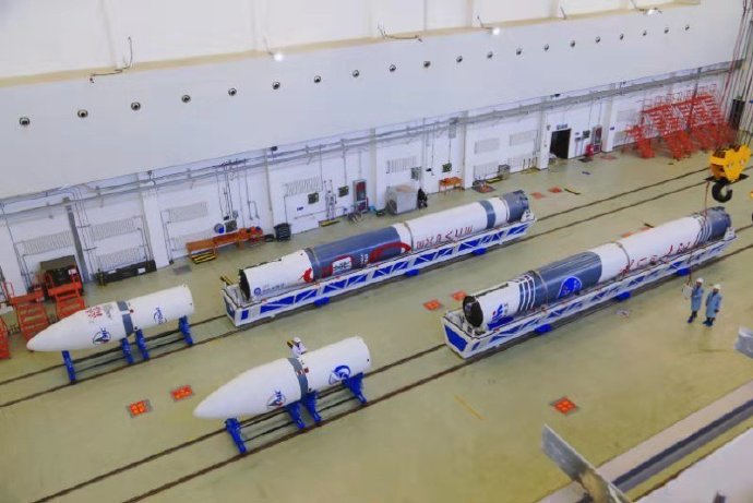
#CNSA #ChinaNationalSpaceAdministration #国家航天局 |#BeltAndRoadinitiative #November2021|#西昌衛星發射中心 # Xichang Satellite Launch Center – Successfully launching the advance iconic #LongMarch2D #ChangZheng2D  #CarrierRocket to deploy the advance high velocity Three #RemoteSensing #EarthSciences  #Satellites.…

On the 6th November  2021 Saturday  in  CNSA _China National Space Administration -China – People’s Republic of China At 1100 morning hours Hong Kong –Beijing Time on an. China successfully launched Satellites using the Long March 2D Chang Zheng 2D carrier rocket at the Xichang Satellite Launch Center Sichuan Province…… successfully launched the  three remote Sensing Earth Sciences satellites named  with the Chang Zheng Long March 2D carrier rocket at 西昌衛星發射中心 Xichang Satellite Launch Center The satellite entered the scheduled orbit smoothly, and the launch mission was a complete success. This mission is the 396th flight of the Chang Zheng- Long March series of carrier rockets….. The Mission was complete Success …. The satellite successfully entered the scheduled orbit and the launch mission was a complete success.

China- People’s Republic of China successfully launched the remote sensing 35  series satellite named  A – B-  C  in which At 11:00 on November 6, the Long March 2D carrier rocket was launched at the Xichang Satellite Launch Center with a three-star launch, and successfully sent the remote sensing 35 satellites A, B, and C into a predetermined orbit.


The satellites A and B of the Remote Sensing No. 35 satellite were developed by the No. 5 Academy of China Aviation; and the Satellite C was developed by the No. 8 Academy of China Aviation. They are mainly used in scientific experiments, land and resources surveys, agricultural production estimates, and disaster prevention and mitigation.

The number eight  Institute of the Eighth Academy developed the battery on the rocket and the power subsystem of the remote sensing 35A and C satellites The main use of the remote sensing 35 satellite A/B/C this time is In the fields of scientific experimentation, land and resources survey, agricultural production estimation, disaster prevention and mitigation, etc. The A and B satellites were developed by the Aerospace Dongfanghong Satellite Co., Ltd., which is affiliated to the 5th Academy of China Aerospace Science and Technology Group , and the C satellites were developed by the 509th Research Institute of the 8th Academy of Aerospace Science and Technology

The International Iconic Chang Zheng –Long March 2D Yao 63 uses the 3.35m diameter fairing series solution for the first time, the super high version of the fairing! With numerous improvements  …… In order to further improve economic benefits and maximize carrying capacity, the Chang Zheng –Long March 2D Yao 63 rocket that launched the remote sensing satellite 35 uses the 3.35-meter diameter fairing for the first time. The size (about 2.5 meters in diameter) makes the height of the entire arrow reach the historical maximum. The height of the star cover assembly has reached 13.4 meters, which is equivalent to the height of 4-5 floors. Feasibility presents a huge challenge. In order to solve the problem that the assembly can pass through the gate of the assembly plant during transportation, the support cabin of the middle layer satellite is creatively designed upside down, and therefore the height of the load cabin is reduced, which can save 70 kilograms of transportation capacity. Payload. At the same time, in order to meet the requirements of satellite low impact, weight reduction and simple interface, the rocket is equipped with a low impact four-point separation device separated by a separation nut to ensure the safety of the satellite separation process.
After the whole rocket is lengthened, more stringent requirements are put forward on the stability of the rocket. After multiple rounds of iterations, affected by the changes in the structural characteristics of the whole rocket, the sensitive attitude rate gyro is repositioned to ensure the stability of the rocket during the entire flight.


This mission is the first mission of the Chang Zheng –Long March 2D Yao 63 carrier rocket in Xichang in 2021. To this end, the test team did a lot of ground equipment restoration work and self-inspection work after entering the site, and re-layer ground measurement, launch and control equipment to ensure that the launch site’s mission was advanced in time; at the same time, the model continued to optimize the launch site’s work process.

Images and visual are from Weibo and their Respectives..

#CNSA #ChinaNationalSpaceAdministration #国家航天局 | #BeltAndRoadinitiative #November2021|#太原卫星发射中心  #TaiyuanSatelliteLaunchCenter  – Launching of the International Iconic #LongMarch6  #ChangZheng6  #CarrierRocket deploying the #EarthSciences  #Satellites #Guangmu #SDGSAT1 #GuangmuEarthScienceSatellite for #UnitedNations  2030 Agenda for Sustainable Development…

At 1019 Hours Morning Hong Kong Beijing Time  on a very clear 5th November 2021 Friday 2021, China- People’s Republic of China- CNSA –China National Space Administration   Successfully launched  the Long March 6 Chang Zheng 6 carrier rocket at the Taiyuan Satellite Launch Center Shanxi Province   China successfully launched Long March – Chang Zheng 6 carrier rocket at the Taiyuan Satellite Launch Center to successfully integrate the Sustainable Development Science Satellite 1 – SDGSAT-1, also known as Guangmu Earth Science Satellite The satellite was sent into a predetermined orbit, and the launch mission was a complete…. The mission is the 395th flight of the Chang Zheng -Long March series of carrier rockets …. In which the scientific satellite that will help meet the UN Sustainable Development Goals (SDGs)…..

The Chang Zheng -Long March 6 and Yao-8 Launch Vehicle  The  Chang Zheng – Long March 6 launch vehicle is a cryogenic liquid three-stage launch vehicle developed by the Eighth Academy of Aerospace Science and Technology Group. It has the ability to launch multiple types of satellites with different orbital requirements and can be implemented. Launched by a single or multiple satellites with a single arrow, its sun-synchronous circular orbit carrying capacity can reach 1.0 tons (orbital height of 700 kilometers). …..

Launching the 广目 Geoscience Satellite Launch Success Four battles and four victories! Today’s launch is the fourth launch of the Long March 6 carrier rocket this year. So far, the Long March 6 has successfully completed the annual launch mission of this model. This launch is the 395th launch of the Long March series of carrier rockets, the 144th flight test of the Long March series of carrier rockets developed by the Eighth Academy of Sciences, and the 8th launch of the Long March 6 carrier rocket.

Guangmu Earth Science Satellite Launched Successfully  Sustainable Development Science Satellite 1 (SDGSAT-1, also known as Guangmu Earth Science Satellite) is the world’s first scientific satellite dedicated to serving the “United Nations 2030 Agenda for Sustainable Development” and also the Chinese Academy of Sciences The first earth science satellite was developed by the Institute of Microsatellite Innovation of the Chinese Academy of Sciences, with the Shanghai Institute of Technical Physics of the Chinese Academy of Sciences, Changchun Institute of Optics and Fine Mechanics, Institute of Aerospace Information Innovation and National Space Science Center as the main participating units.

The satellite project is included in the management of the “Space Science Pilot Project”, and the International Research Center for Sustainable Development Big Data (CBAS) serves as the main user of the satellite. The satellite has developed a dedicated platform for earth science satellites and three payloads: Thermal Infrared Imager (TIS), Urban Low-light Imager (GIU) and Offshore Multi-spectral Imager (MII). Human activities are carried out through satellite all-day coordinated observations. The precise detection of regional “energy consumption, human settlements, coastal and port environment”, to achieve the fine description of “traces of human activities”, to quantify the interaction between humans and nature, and to provide monitoring, evaluation and scientific research for the realization of the global sustainable development goals Data support. This mission is the 39th satellite launch of the Institute of Microsatellite Innovation, Chinese Academy of Sciences. Up to now, 75 satellites have been successfully launched, including manned space companion satellites, remote sensing 30 satellites, BeiDou navigation satellites, dark matter particle detection satellites, quantum science experimental satellites, and global carbon dioxide monitoring satellites, covering communications, navigation, remote sensing, and science. And micro-nano and other fields.

Images and visuals are from Weibo and their respectives

#CNSA #ChinaNationalSpaceAdministration #国家航天局 | #BeltAndRoadinitiative | International Iconic #LongMarch #ChangZheng4C #Carrier Rocket deploying November an advance #Gaofen12 #EarthSciences #OpticalSatellite

On the morning of 28th November 2019, launching from one of many CNSA –China National Space Administration   launching on 0752 Beijing Morning time.. Launching from the Taiyuan Satellite Launch Centre in which is located in Northern China, Shanxi Province, the launch when without any issues..

Launching from one of its launching Carrier Rocket the Long March 4C- Chang Zheng 4C, launching deploying from by the SAST – Shanghai Academy of Spaceflight Technology in which is sister company organisation of the CAST- China Aerospace Science and Technology Corporation.. Launching as its 320th flight ….


The Gaofen12 manufacturer is CAST – China Academy of Space Technology also in collaboration with its associate agency with CHEOS- China High Resolution Earth Observation System in which is design Built on a CAST 2000 Design Heritage Earth Sciences, in which is design for Translating Gaofen is High Resolution, also known as CHEOS- China High Resolution Earth Observation System, in which provisions in the real time observational data analysis of with high resolution multi spectra equipment imaging system in analysis for assessing environmental disaster warning, emergency response also for the protection for ecological, also providing support for infrastructure construction, transportation for various purpose of the Belt And Road initiative  … one of many specifications of the Gaofen 10 Earth Sciences satellite is The high-resolution satellite is a large-scale remote sensing satellite system for the national science and technology major special arrangement of the microwave remote sensing satellite, the ground pixel resolution is up to sub-meter …

Image and visuals are from Weibo..

#MadeInChina #中國製造 #中國 |#EXpace #CASIC #ChinaAerospaceScienceAndIndustryCorporation | launching a #Kuaizhou1A #KZ1A #CarrierRocket deploying an advance #Jilin1 #Gaofen02A #EarthSciences #RemoteSensing #ObservationSatellite…

On 13th November 2019, CNSA-China National Space Administration subsidiary Organisation CASIC –China Aerospace Science an Industry Corporation   launched a by Kuaizhou-1A (KZ-1A), a carrier rocket at 11:40 a.m. (Beijing Time) on a very clear day in which deploying an Earth Sciences remote sensing optical observation satellite..

The Kuaizhou-1A (KZ-1A), a carrier rocket is design to carry to deploy payload type of micro satellites, in which delivering the payload into LEO- Low Earth Orbit… Launching from the Jiuquan Satellite Launch Center in Jiuquan, northwest China’s Gansu Province of the People’s Republic of China- China ….


The Jilin-1 Gaofen 02A, which belongs to the Jilin-1 satellite constellation, featuring a highly advance new optical earth sciences remote sensing observation satellite, in which The Jilin-1 Gaofen 02A satellite is developed by the Chang Guang Satellite Technology Co., Ltd., in which also featuring a high resolution high data velocity broadband communications transmission.. Wednesday’s launch was the second mission of the KZ-1A rocket in 2019. It had previously completed three commercial launches from January 2017 to August 2019….. During this launch currently completing a constellation network of thirteen Jilin-1 satellites…. Jilin one. In which are designated as Earth Sciences remote satellites in which are provisionments with providing observationally data analysis of forestry, marine navigation, weather disaster forecasting management for its clients.. In which it forms a constellation network further of currently of thirteen..

#CNSA #ChinaNationalSpaceAdministration #国家航天局 #BeltAndRoadinitiative | International Iconic #LongMarch4B ChangZheng4B #CarrierRocket launching- deploying advance high resolution #EarthSciences #ObservationSatellite #GaofenSeven …

On 3rd November 2019, CNSA China National Space Administration, have successfully launch the International Iconic reliable Long March 4B  in which is also known as Chang Zheng 4B from the Taiyuan Satellite launch centre one of many CNSA launch centre complexes, launching from the Shanxi Province, Northern People’s Republic of China-China in a very late Morning 1122 Hour Beijing Time..

Gaofen seven is an dedicated Earth observation Satellite for Earth Sciences, in which its Launching the Iconic CNSA – Long March 4B or known as Chang Zheng 4B, manufactured by SAST- Shanghai Academy of Spaceflight Technology … launching the Long March 4B Carrier Rocket the staff working hard during their National Day seven day bank holiday.. In which a previous launch working on National Day does not rest on first of October 2019…. in which the launching and delivery of the Long March 4C with a Gaofen ten satellite…

The Gaofen Seven  manufacturer is CAST – China Academy of Space Technology also in collaboration with its associate agency with CHEOS- China High Resolution Earth Observation System in which is design Built on a CAST 2000 Design Heritage Earth Sciences, in which is design for Translating Gaofen is High Resolution, also known as CHEOS- China High Resolution Earth Observation System, in which provisions in the real time observational data analysis of with high resolution multi spectra equipment imaging system in analysis for assessing environmental disaster warning, emergency response also for the protection for ecological, also providing support for infrastructure construction, transportation for various purpose of the Belt And Road initiative  … one of many specifications of the Gaofen 10 Earth Sciences satellite is The high-resolution satellite is a large-scale remote sensing satellite system for the national science and technology major special arrangement of the microwave remote sensing satellite, the ground pixel resolution is up to sub-meter …


credit Images and visuals are from Weibo Our Space