#CNSA #ChinaNationalSpaceAdministration #国家航天局 |#BRI #November2023| #酒泉卫星发射中心 #JiuquanSatelliteLaunchCenter – #ChangZheng2C #LongMarch2C #CarrierRocket launched #Haiyang301. – New generation of ocean water color observation satellite…

On the 1155  morning 16TH November  2023 Thursday  Hours Hong- Kong SAR – Beijing time CNSA –China National Space Administration , China, People’s Republic of China. Successfully launched the Yonggan 33 Remote Sensing satellite with the Chang Zheng- Long March 2C Jiuquan Satellite Launch Center, Inner Mongolia, China, People’s Republic of China, and then successfully launched a new generation of ocean water color observation satellite into the predetermined orbit, and the launch mission was completed successfully.


【congratulate! 亚洲水色Observation Satellite Successfully Launched  ]

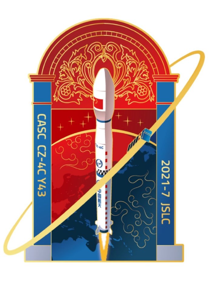
At 11:55 on November 16, my country successfully launched a new generation of ocean satellite at the Jiuquan Satellite Launch Center using a launch vehicle composed of the Long March 2C basic stage and the Yuanzheng 1S upper stage.  Water color observation satellite Haiyang-301. The satellite’s indicators have reached the advanced level of international water color remote sensing satellites, can meet the main business needs of my country’s marine environment monitoring, and can serve major national strategic needs such as ecological civilization construction, smart ocean engineering construction, and the “One Belt, One Road” initiative.

At 11:55 on November 16, my country successfully launched the new generation ocean water color observation satellite Haiyang-301 from the Jiuquan Satellite Launch Center using a launch vehicle composed of the Long March-2C basic stage and the Yuanzheng-1S upper stage. The satellite’s indicators have reached the advanced level of international water color remote sensing satellites, can meet the main business needs of my country’s marine environment monitoring, and can serve major national strategic needs such as ecological civilization construction, smart ocean engineering construction, and the “One Belt, One Road” initiative.

The long-distance propylene rocket currently has two states: the basic type and the Yuanzheng-1S upper stage configuration.
In view of the heavy weight and high orbit of the satellite, this mission uses the Long March 2C/Yuanzheng 1S configuration rocket, which has the capability of launching multiple satellites with one rocket and deploying constellations. This is the sixth launch of this configuration of rocket. This rocket optimizes a number of technologies, effectively improving the accuracy of the debris landing point and the accuracy of the entire flight time.

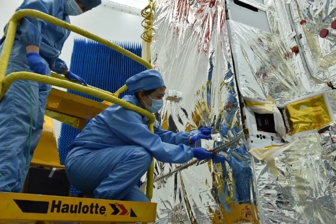
The new generation of ocean water color observation satellites are scientific research satellites in the national civil space infrastructure. The satellite is equipped with payloads such as an ocean water color and water temperature scanner, a medium-resolution programmable imaging spectrometer, and a coastal zone imager. It can improve the spatial resolution and spectral resolution of my country’s ocean water color observations, expand the detection spectral band, and achieve rapid coverage of global ocean water color observations. , improve the application level of my country’s ocean remote sensing satellites, and operate in orbit with the Haiyang-1 C/D satellite to promote the sustainable development of my country’s ocean water color remote sensing business. Compared with the previous generation of Haiyang-1 satellites, Haiyang-3-01 has achieved leaps and bounds in terms of ocean water color product types, product quality, and detection capabilities. The satellite has a design life of 8 years and can carry out high-precision, multi-spectral, and long-term sequence observations of global ocean waters to meet applications in natural resources, ecological environment, transportation, meteorology and other industries, help protect the marine environment, and safeguard my country’s maritime rights and interests.

The National Space Administration is responsible for the organization and management of the new generation ocean water color observation satellite project, the organization and coordination of major matters, and the approval of launch licenses; the Ministry of Natural Resources is the lead user department, and the main user departments include the Ministry of Ecology and Environment, the Ministry of Transport, the China Meteorological Administration, etc., responsible for their respective Application system construction and operation; the National Satellite Ocean Application Center of the Ministry of Natural Resources is responsible for the construction and operation of ground systems; China Academy of Space Technology of China Aerospace Science and Technology Corporation and China Academy of Launch Vehicle Technology are responsible for the overall development of satellite systems and launch vehicle systems respectively.

This mission is the 497th launch of the Long March series of launch vehicles.

Visuals are from their respectives also from CNSA- China National Space Administration

#MadeInChina #中國製造 #ExPace | #July2023| #CASIC Rocket Technology Company #Expace #Wuhan #CarrierRocketCompany #CarrierRocket #快舟一号  #Kuaizhou1A  #KX1A  YAO 21 Carrier Rocket Successfully launched #Tianmu1 #WeatherSatellite #MeteorologicalSatellite constellation…. On #InternationalMoonDay

Currently at the moment中國製造 Expace Technology Corporation- a CASIC -China aerospace science and industry corporationhas been very busy in building a New Carrier Rocket Factory in Wuhan National Aerospace Industrial Base in which the base will be in operations in May 2020   Kuaizhou Rocket Industrial Park that forms the manufacturing of twenty plus more Kuaizhou Rockets also its other sister larger carrier rockets in process of The assembly test capability of 20 solid launch vehicles……in which is now in operation……

快舟一号On a Clear blue Skies Day on Jiuquan Satellite launch Centre, Inner Mongolia, China, People’s Republic of China… 中國製造 Expace Technology Corporation.Kuaizhou-1A YAO 21 successfully launched Tianmu-1 meteorological constellation 07-10 satellites  At 11:20 Hong Kong SAR- Beijing time today, the Kuaizhou-1A solid carrier rocket was ignited and blasted off at the Jiuquan Satellite Launch Center, with “one Carrier Rocket and four satellite” The Tianmu-1 meteorological constellation 07-10 satellite were sent into the predetermined orbit by means of the method, and the launch mission was a complete success. Tianmu-1 Meteorological Constellation 07-10 is a remote sensing detection satellite developed by a system company affiliated to CASIC, which is mainly used to obtain information on global atmospheric environment elements. After completion, it can realize the three-dimensional and integrated global all-weather ocean, atmosphere, and ionosphere probing.

Images and visuals are from their respectives..

#CNSA #ChinaNationalSpaceAdministration #国家航天局 |#BRI #April2023 |  #JiuquanSatelliteLaunchCenter launched on the International Icon #ChangZheng4B  #LongMarch4B  Y51  #CarrierRocket successfully launch #Fengyun- 3G #MeteorologicalSatellite, #Satellites….

On the 16th April 2023 clear 0936 Hours Hong Kong SAR- Beijing time , the Belt and Road Initiative CNSA –China National Space Administration  launching from Jiuquan Satellite Launch Center – Inner Mongolia –China – People’s Republic of China deployed launched the Chang Zheng –   The Chang Zheng – Long March 4B Y51 carrier rocket.. This launch is the 471st launch of the Long March series of launch vehicles.

Successfully launched the Fengyun-3G satellite, and my country has entered a new stage of active precipitation measurement and detection..  At 9:36 Hong Kong SAR- Beijing Time  today, the Long March 4B Yao 51 carrier rocket was ignited and blasted off at the Jiuquan Satellite Launch Center, successfully carrying my country’s first The first precipitation measurement satellite Fengyun-3G was sent into the predetermined orbit, and the launch mission was a complete success……  


Fengyun-3G satellite is China, People’s Republic of China first low-orbit non-sun-synchronous inclined orbit meteorological satellite, and it is also my country’s first and the third international active precipitation measurement satellite. The satellite is equipped with 4 units/sets of active precipitation measurement radar, microwave imager, medium-resolution spectral imager, and global navigation satellite occultation detector, which will fill the gap in domestic precipitation three-dimensional tomographic detection data. So far, my country has successfully launched a total of 20 “two-generation and four-type” Fengyun meteorological satellites.

The FY-3 G star is equipped with my country’s first set of “airborne rain gauge” – the satellite-borne Ku and Ka dual-frequency precipitation measurement radar, which transmits wireless electromagnetic wave signals to the atmosphere and receives the reflection signals of precipitation particles at different altitudes in the atmosphere to achieve vertical Detection of directional precipitation: Using the scanning ability of the radar in the cross-track direction, the detection of precipitation in the horizontal direction is realized, just like the “CT” scanning of atmospheric precipitation, to obtain the fine three-dimensional structure information of precipitation.

Images and visuals are from their Respectives CMS China Manned SpaceCNSA-China National Space Administration

#CNSA #ChinaNationalSpaceAdministration #國家航天局|#BRI #March2023 |#ChineseAcademyofSciences #NationalAstronomicalObservatory #EinsteinProbe X-ray astronomical #Satellite – pinpoint the source of gravitational waves discovering the mysterious universe planned launch this year.  

國家航天局CNSA –China National Space Administration  China, People’s Republic of China plans to launch the Einstein probe at the end of this year China plans to launch a new X-ray astronomical satellite, the Einstein probe, at the end of 2023. It is expected to capture the first ray of light from a supernova explosion and help search and precise positioning the source of gravitational waves, discovering more distant, fainter celestial objects and fleeting mysterious phenomena in the universe. The satellite project has entered the final stage of positive development.

The X-ray Imaging Laboratory of the National Astronomical Observatory of the Chinese Academy of Sciences has been developing lobster eye X-ray imaging technology since 2010. After years of key technology research, it finally made a breakthrough, fully mastered the technology, and has completely independent intellectual property rights. The team carried out the test and verification of this technology on the space new technology test satellite launched in July 2022, and obtained and publicly released the wide-field X-ray focused imaging sky map for the first time in the world.

Yuan Weimin, the chief scientist of the Einstein Probe Satellite and a researcher at the National Astronomical Observatories of the Chinese Academy of Sciences, introduced at the recently held 35th National Space Exploration Symposium that the satellite project has entered the final development stage.

Inspired by the peculiar focusing imaging principle of lobster eyes, scientists have designed a special new type of X-ray telescope, which has a large observation field of view and higher detection sensitivity.

“That is to say, this kind of telescope can see the darker and farther universe while seeing a wide range. It is thanks to the lobster eye telescope technology that the Einstein Probe satellite can see the currently known universe.” There are very few soft X-ray bands for large-field, high-sensitivity, and fast time-domain survey monitoring.” Yuan Weimin said.

The X-ray Imaging Laboratory of the National Astronomical Observatory of the Chinese Academy of Sciences has been developing lobster eye X-ray imaging technology since 2010. After years of key technology research, it finally made a breakthrough, fully mastered the technology, and has completely independent intellectual property rights. The team carried out the test and verification of this technology on the space new technology test satellite launched in July 2022, and obtained and publicly released the wide-field X-ray focused imaging sky map for the first time in the world

Images and visuals are from their Respectives CMS China Manned SpaceCNSA-China National Space Administration

#CNSA #ChinaNationalSpaceAdministration #国家航天局 |#BeltAndRoadinitiative #July2021|#酒泉衛星發射中心 #JiuquanSatelliteLaunchCenter Launch of the International Iconic #LongMarch4C #ChangZheng4C #长征四 #CarrierRocket deploying an advance #WeatherSatellite #EarthSciences #Fengyun3E …

On 5th July 2021 Monday 0728  a summery clear morning Hong Kong SAR- Beijing Time-  CNSA –China National Space Administration  on which from Jiuquan Satellite launch Center – Inner Mongolia- China-People’s Republic of China… It  successfully launched the international ionic Long March 4C- Chang Zheng 4C Carrier Rocket  in which July 2021 there’s been numerous launches in which celebrating the 100th CPC year anniversary more in China – People’s Republic of China..

Launching scheduling in which this mission is the 377th flight of the Long March series of carrier rockets….deploying on the sending the Fengyun-3 E star into its intended orbit , The launch was a complete success…. The Long March 4 series is developed by the Eighth Academy of Sciences…

The Fengyun-3 E weather earth Science successfully launched deployed..! in which the it’s provision design is as a  Service emergency weather event decision-making evaluation . The Fengyun-3 E satellite is mainly used for weather forecasting, climate forecasting, environmental monitoring and disaster prevention and mitigation, etc. It provides weather detection information for the world, and provides reliable weather data for government departments at all levels to make decisions and assessments of sudden weather events. Fengyun-3 E satellite. E FY FY-III satellite is a satellite of the family’s first dawn orbit meteorological satellite, but also the world’s first implementation of business operations at dawn sun-synchronous orbit meteorological satellite 

Developed by the Eighth Academy of China Aerospace Science and Technology Corporation (Shanghai Institute of Aerospace Technology) has a total weight of 2.69 tons and runs on the earth’s twilight boundary. On the sun-synchronous orbit above, it can fill the gap of satellite observation data in the 6-hour assimilation window of global numerical weather prediction, achieve 100% coverage of global observation data, significantly improve the accuracy of numerical weather prediction, and effectively improve China’s weather forecast prediction, response to climate change, Build disaster prevention and mitigation systems, establish environmental and ecological monitoring, and space weather forecast and early warning capabilities.


The Fengyun-3 E star is loaded with 11 payloads, including 3 newly developed instruments represented by wind field measurement radar, solar irradiance spectrometer and solar X-EUV imager, 7 upgraded instruments and 1 inherited Upgrade the instrument. Among the three newly added payloads, the wind field measurement radar is the first active detection radar carried by the Fengyun series satellites. It is a dual-frequency, dual-polarization cone-scanning microwave radar. It mainly obtains global ocean surface wind field information through sea surface backscatter measurement. ; The solar irradiance spectrometer measures the solar spectral irradiance daily through the three channels of ultraviolet, visible and infrared, and obtains the characteristics of solar spectral irradiance. The measurement data will be widely used in solar physics, atmospheric physics and climate physics. Scientific research; the solar X-EUV imager uses solar radiation in the X-ray band and extreme ultraviolet band radiation to achieve long-term, continuous, high-time-resolved full-plane and low-corona imaging observations of the sun, and obtain high-resolution images of the sun. Space weather forecast provides a more accurate reference.


Among the 7 upgraded instruments, the medium-resolution spectral imager (low-light type) has a new low-light channel, which can obtain images covering the world’s 100-meter level (250m*2600km) spatial resolution, which is 33% higher than the previous generation product. %, is China’s most advanced quantitative global low-light detection instrument; infrared hyperspectral atmospheric sounder (type Ⅱ) medium-wave and short-wave sensitivity will be more than doubled than before; microwave thermometer (type Ⅲ) added 4 channels , The number of detection channels has reached 17; the GNSS-R sea surface wind field detection function has been added to the global navigation satellite occultation sounder (Type II), which will realize the three-dimensional monitoring of the ionosphere, atmosphere and sea surface wind field. For the first time, the integrated detection of GNSS occultation and GNSS-R remote sensing has been realized; the solar radiation monitor (international comparison type) used to monitor changes in solar irradiance and capture solar activity signals is newly added to the Swiss DARA radiometer, which will be realized for the first time in Chinese and foreign instruments Simultaneous observation in orbit. 

Images and visuals are from Weibo..