#CNSA #ChinaNationalSpaceAdministration #国家航天局 |#BRI  #March2023 |#西昌衛星發射中心 #XichangSatelliteLaunchCenter – Successfully launching the advance iconic #ChangZheng3B #LongMarch3B Y90  #CarrierRocket deploying advance Gaofen 13-02  #EarthSciences #RemoteSensing #EnivormentalSatellite  #Satellite The third launch within a week!

On the 17th March  2023  in  CNSA _China National Space Administration -China – People’s Republic of China At 1633 hours Hong Kong –Beijing Time China- People’s Republic of China launch the Chang Zheng – Long march 3B  Carrier Rocket launching from station form Xichang Satellite Launch Center Sichuan Province…..Deploying the Gaofen 13-02  Earth Sciences Environmental satellite….

Long March 3B successfully launched the Gaofen 13-02 satellite successfully launch the Gaofen 13-02 satellite into space, and the satellite went smoothly Entering the predetermined orbit, the launch mission was a complete success. The satellite is mainly used in the fields of land census, crop yield estimation, environmental governance, weather early warning and forecasting, and comprehensive disaster prevention and mitigation. This mission is the 468th flight of the Long March series of launch vehicles!

The 02 satellite is a high-orbit optical remote sensing satellite, which is mainly used in emergency disaster reduction, land census, ocean observation, environmental governance, meteorological observation and other fields, and can provide information services for national economic construction.

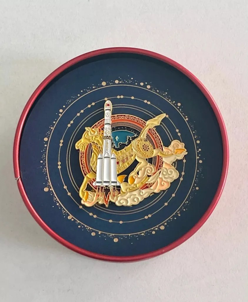
Chang Zheng – Long march 3B  Carrier Rocket yao 90 launches high score 13th No. 02 satellite mission badge: This badge is inspired by the historical allusion of a horse stepping on a flying swallow. Ma Ta Feiyan is a magical and rare treasure in the history of ancient sculpture art in my country. It is a landmark building in Xichang. As an emblem element, it implies the rapid development of China’s aerospace industry and the tenacious and indomitable spirit of astronauts.
The main body of the emblem is the Chang Zheng – Long march rocket, the earth is in the center of the picture, auspicious clouds surround the main body, and the stars mark the launch site, which means that one arrow and one star will be launched from here, and go forward bravely, just like astronauts bravely climbing the peak of science and technology, to write China’s aerospace industry The new chapter dares to overcome all difficulties and obstacles…..

Images and visuals are from their Respectives CMS China Manned SpaceCNSA-China National Space Administration

#CNSA- China National Space Administration #国家航天局 | #BeltAndRoadinitiative #LongMarch4C Carrier Rocket launching three #Gaofen1 Imagining Satellites in one launch… in providing extreme real time weather information..


On 31 March 2018 Saturday, CNSA – China National Space Administration has launched successfully three satellites within one payload…  from its Northern China province of Shanxi…. In which is the TSLC- Taiyuan Satellite Launch Center, in which is a testing and one of many key launch facilities for the CNSA in the Kelan County Xinzhou in which has been founded on 1966 March in which providing to be a testing facilities for designs with various different carrier rockets…  the first was Gaofen 1-one launched on April 2013..

The launch of the CNSA’s Long March 4C with three Gaofen one series weather information satellites..

Launching from the reliable Long March 4C carrier Rocket on a clear Saturday Day… in which is the 270th anniversary flight mission for the Long March 4C series… The three payload satellites in which is the three set of Gaofen one series satellites- Gaofen having a operation services life cycle of in between five to eight years averagely… in which designed, manufactured by China SpaceSat Co limited built on a CAST-2000 bus design.. As a planetary observation Satellite Gaofen one-two, three four launching into Sun Synchronous Orbit…. Waiting is the next series of Gaofen series is five, six, seven then the next is the eighth, ninth, then the tenth…

Translating Gaofen is High Resolution, also known as CHEOS- China High Resolution Earth Observation System, in which provisions in the real time observational data analysis of with high resolution multi spectra equipment imaging system in analysis for assessing environmental disaster warning, emergency response also for the protection for ecological, also providing support for infrastructure construction, transportation…….  With the precession optically of two meters in providing support… the three are place in 120 Km apart, in a 120 degrees orbital plane with a 645 Kilometer attitude above Earth…………………